Haputale geodata
Haputale (Uva) is a populated place; located in Sri Lanka in Asia/Colombo (GMT+5.5) time zone. With population of 4,721 people, there are 67 cities with bigger population in this country. Compared to other cities in Sri Lanka, 73.7% of cities are located further ↑North; 82.9% of cities are located further ←West and 98.7% of cities have lower elevation than Haputale. Note1
Administrative division(s):
- Level 1: Uva
- Level 2: Badulla District
- Level 3: Haputale Division
- Level 4: Magiripura


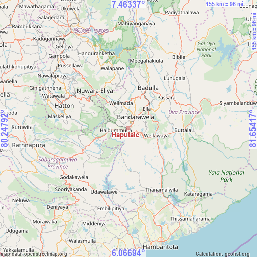
Haputale GPS coordinates[2]
6° 45' 56.376" North, 80° 57' 3.744" East
| Map corner | latitude | longitude |
|---|---|---|
| Upper-left | 7.46337°, | 80.24792° |
| Center: | 6.76566°, | 80.95104° |
| Lower-right: | 6.06694°, | 81.65417° |
| Map W x H: | 155.3×155.3 km | = 96.5×96.5mi |
| max Lat: | 9.81667° ⇑73.7% North |
| Haputale: | 6.76566° |
| min Lat: | ⇓26.3% South 5.92825° |
| min Long | Haputale | max Long |
| 79.79528° | 80.95104° | 81.83472° |
| W 82.9%⇐ | ⇒17.1% E |
Elevation
Elevation of Haputale is 1449 m = 4754 ft, and this is 1291.6 m = 4238 ft above average elevation for this country.
| Max E: |
1868 m = 6129 ft | 1.3% |
| Haputale | 1449 m 4754 ft | |
| Avg. | 157.4 m = 516 ft | |
Min E: |
1 m = 3 ft | 98.7% |
See also: Sri Lanka elevation on elevation.city.
Geographical zone
Haputale is located in North Torrid zone (between Equator and Tropic of Cancer). Distance of Equator is 752.3 km =467.5 mi to South.| Distance of | km | miles | from Haputale |
|---|---|---|---|
| North Pole | 9254.8 | 5750.7 | to North |
| Arctic Circle | 6648.9 | 4131.4 | to North |
| Tropic Cancer | 1853.6 | 1151.8 | to North |
| Equator | 752.3 | 467.5 | to South |


Nearby cities:
15 places around Haputale: (largest is in red/bold)
• Badulla
26.6 km =16.5 mi,  26°
26°
• Ella Town
16.1 km =10 mi,  40°
40°
• Gampola
61.1 km =38 mi,  316°
316°
• Hatton
41.7 km =25.9 mi,  289°
289°
• Kadugannawa
71.9 km =44.7 mi, 319°
• Kandy
68.1 km =42.3 mi,  329°
329°
• Kataragama
57.7 km =35.9 mi,  132°
132°
• Kegalle
86.1 km =53.5 mi,  308°
308°
• Monaragala
45.4 km =28.2 mi,  75°
75°
• Nuwara Eliya
29.4 km =18.3 mi, 320°
• Ratnapura
61.1 km =38 mi,  261°
261°
• Talawakele
37.5 km =23.3 mi,  300°
300°
• Tangalle
84.3 km =52.4 mi,  191°
191°
• Wattegama
58.6 km =36.4 mi,  86°
86°
• Wellawaya
17.1 km =10.6 mi,  100°
100°
Sources, notices
• [Note1] Compared only with cities in Sri Lanka existing in our database
• [Src1] Map data: © OpenStreetMap contributors (CC-BY-SA)
• [Src2] Other city data from geonames.org with taken over terms of usage.
• [Src3] Geographical zone / Annual Mean Temperature by Robert A. Rohde @ Wikipedia
