Kalmunai geodata
Kalmunai (Eastern Province) is a populated place; located in Sri Lanka in Asia/Colombo (GMT+5.5) time zone. With population of 100,171 people, there are 9 cities with bigger population in this country. Compared to other cities in Sri Lanka, 73.7% of cities are located further ↓South; 100% of cities are located further ←West and 73.7% of cities have higher elevation than Kalmunai. Note1


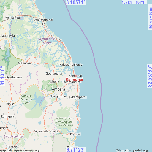
Kalmunai GPS coordinates[2]
7° 24' 32.472" North, 81° 50' 4.992" East
| Map corner | latitude | longitude |
|---|---|---|
| Upper-left | 8.10571°, | 81.1316° |
| Center: | 7.40902°, | 81.83472° |
| Lower-right: | 6.71123°, | 82.53785° |
| Map W x H: | 155.1×155.1 km | = 96.4×96.4mi |
| max Lat: | 9.81667° ⇑26.3% North |
| Kalmunai: | 7.40902° |
| min Lat: | ⇓73.7% South 5.92825° |
| min Long | Kalmunai | max Long |
| 79.79528° | 81.83472° | 81.83472° |
| W 100%⇐ | ⇒0% E |
Elevation
Elevation of Kalmunai is 10 m = 33 ft, and this is 147.4 m = 484 ft below average elevation for this country.
| Max E: |
1868 m = 6129 ft | 73.7% |
| Avg. | 157.4 m = 516 ft | |
| Kalmunai | 10 m = 33 ft | |
Min E: |
1 m = 3 ft | 26.3% |
See also: Kalmunai elevation on elevation.city.
Geographical zone
Kalmunai is located in North Torrid zone (between Equator and Tropic of Cancer). Distance of Equator is 823.8 km =511.9 mi to South.| Distance of | km | miles | from Kalmunai |
|---|---|---|---|
| North Pole | 9183.3 | 5706.2 | to North |
| Arctic Circle | 6577.4 | 4087 | to North |
| Tropic Cancer | 1782.1 | 1107.3 | to North |
| Equator | 823.8 | 511.9 | to South |


Nearby cities:
15 places around Kalmunai: (largest is in red/bold)
• Ampara
20.9 km =13 mi,  233°
233°
• Badulla
98.1 km =61 mi,  240°
240°
• Batticaloa
37 km =23 mi,  334°
334°
• Ella Town
105.3 km =65.4 mi, 235°
• Eravur Town
48.3 km =30 mi, 328°
• Haputale
120.9 km =75.1 mi, 233°
• Kandy
133.1 km =82.7 mi,  264°
264°
• Kataragama
123.7 km =76.9 mi,  206°
206°
• Monaragala
80.3 km =49.9 mi,  221°
221°
• Nuwara Eliya
125.9 km =78.2 mi,  247°
247°
• Polonnaruwa
109 km =67.7 mi,  302°
302°
• Sigiriya
133.7 km =83.1 mi, 296°
• Vakarai
91.9 km =57.1 mi, 331°
• Wattegama
78.3 km =48.7 mi, 209°
• Wellawaya
110 km =68.4 mi, 227°
Sources, notices
• [Note1] Compared only with cities in Sri Lanka existing in our database
• [Src1] Map data: © OpenStreetMap contributors (CC-BY-SA)
• [Src2] Other city data from geonames.org with taken over terms of usage.
• [Src3] Geographical zone / Annual Mean Temperature by Robert A. Rohde @ Wikipedia
