Lib geodata
Lib (Lib Island) is a seat of a first-order administrative division; located in Marshall Islands in Pacific/Majuro (GMT+12) time zone. With population of 115 people, there are 17 cities with bigger population in this country. Compared to other cities in Marshall Islands, 50% of cities are located further ↓South; 79.2% of cities are located further →East and 95.8% of cities have lower elevation than Lib. Note1


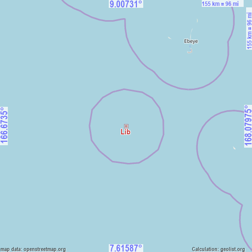
Lib GPS coordinates[2]
8° 18' 43.956" North, 167° 22' 35.832" East
| Map corner | latitude | longitude |
|---|---|---|
| Upper-left | 9.00731°, | 166.6735° |
| Center: | 8.31221°, | 167.37662° |
| Lower-right: | 7.61587°, | 168.07975° |
| Map W x H: | 154.7×154.7 km | = 96.1×96.1mi |
| max Lat: | 11.34735° ⇑50% North |
| Lib: | 8.31221° |
| min Lat: | ⇓50% South 4.58199° |
| min Long | Lib | max Long |
| 162.33733° | 167.37662° | 171.73502° |
| W 20.8%⇐ | ⇒79.2% E |
Elevation
Elevation of Lib is 15 m = 49 ft, and this is 5.3 m = 17 ft above average elevation for this country.
| Max E: |
16 m = 52 ft | 4.2% |
| Lib | 15 m 49 ft | |
| Avg. | 9.7 m = 32 ft | |
Min E: |
5 m = 16 ft | 95.8% |
See also: Marshall Islands elevation on elevation.city.
Geographical zone
Lib is located in North Torrid zone (between Equator and Tropic of Cancer). Distance of Equator is 924.2 km =574.3 mi to South.| Distance of | km | miles | from Lib |
|---|---|---|---|
| North Pole | 9082.8 | 5643.8 | to North |
| Arctic Circle | 6476.9 | 4024.6 | to North |
| Tropic Cancer | 1681.7 | 1045 | to North |
| Equator | 924.2 | 574.3 | to South |


Nearby cities:
15 places around Lib: (largest is in red/bold)
• Ailuk
355.8 km =221.1 mi,  53°
53°
• Airuk
196.3 km =122 mi,  125°
125°
• Aur
417.7 km =259.5 mi,  92°
92°
• Ebaye
65.1 km =40.5 mi,  37°
37°
• Jabat
186.8 km =116.1 mi,  109°
109°
• Jabor
365 km =226.8 mi,  136°
136°
• Kili
353.7 km =219.8 mi,  147°
147°
• Lae
139.9 km =86.9 mi,  298°
298°
• Likiep
270.9 km =168.3 mi, 51°
• Loen
112.3 km =69.8 mi,  123°
123°
• Namdrik
312.1 km =193.9 mi,  165°
165°
• Rongelap
321.4 km =199.7 mi,  350°
350°
• Ujae
190.2 km =118.2 mi,  291°
291°
• Wotho
254.9 km =158.4 mi,  323°
323°
• Wotje
338.9 km =210.6 mi,  67°
67°
Sources, notices
• [Note1] Compared only with cities in Marshall Islands existing in our database
• [Src1] Map data: © OpenStreetMap contributors (CC-BY-SA)
• [Src2] Other city data from geonames.org with taken over terms of usage.
• [Src3] Geographical zone / Annual Mean Temperature by Robert A. Rohde @ Wikipedia
