Sühbaatar geodata
Sühbaatar (Selenge) is a seat of a first-order administrative division; located in Mongolia in Asia/Ulaanbaatar (GMT+8) time zone. With population of 24,235 people, there are 10 cities with bigger population in this country. Compared to other cities in Mongolia, 96.6% of cities are located further ↓South; 72.1% of cities are located further ←West and 100% of cities have higher elevation than Sühbaatar. Note1


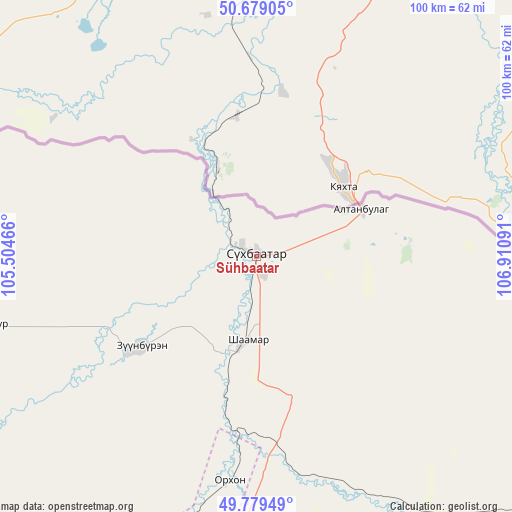
Sühbaatar GPS coordinates[2]
50° 13' 53.004" North, 106° 12' 28.008" East
| Map corner | latitude | longitude |
|---|---|---|
| Upper-left | 50.67905°, | 105.50466° |
| Center: | 50.23139°, | 106.20778° |
| Lower-right: | 49.77949°, | 106.91091° |
| Map W x H: | 100×100 km | = 62.1×62.1mi |
| max Lat: | 51.50725° ⇑3.4% North |
| Sühbaatar: | 50.23139° |
| min Lat: | ⇓96.6% South 42.84199° |
| min Long | Sühbaatar | max Long |
| 89.14358° | 106.20778° | 118.51014° |
| W 72.1%⇐ | ⇒27.9% E |
Elevation
Elevation of Sühbaatar is 619 m = 2031 ft, and this is 797.5 m = 2616 ft below average elevation for this country.
| Max E: |
2800 m = 9186 ft | 100% |
| Avg. | 1416.5 m = 4647 ft | |
| Sühbaatar | 619 m = 2031 ft | |
Min E: |
619 m = 2031 ft | 0% |
See also: Mongolia elevation on elevation.city.
Geographical zone
Sühbaatar is located in North temperate zone (between Tropic of Cancer and the Arctic Circle). Distance of this North polar circle is 1816 km =1128.4 mi to North.| Distance of | km | miles | from Sühbaatar |
|---|---|---|---|
| North Pole | 4421.9 | 2747.6 | to North |
| Arctic Circle | 1816 | 1128.4 | to North |
| Tropic Cancer | 2979.3 | 1851.3 | to South |
| Equator | 5585.2 | 3470.5 | to South |


Nearby cities:
15 places around Sühbaatar: (largest is in red/bold)
• Altanbulag
22.7 km =14.1 mi,  65°
65°
• Bugant
85.5 km =53.1 mi,  147°
147°
• Bulagtay
106.3 km =66.1 mi,  118°
118°
• Darhan
85.3 km =53 mi,  193°
193°
• Delgerhaan
16.3 km =10.1 mi, 185°
• Dzelter
83.1 km =51.6 mi,  276°
276°
• Enhtal
124.7 km =77.5 mi,  208°
208°
• Hongor
113.6 km =70.6 mi, 191°
• Hushaat
91.7 km =57 mi, 207°
• Huurch
57.9 km =36 mi,  255°
255°
• Jargalant
29.6 km =18.4 mi,  231°
231°
• Nart
134.4 km =83.5 mi, 206°
• Nomgon
121.1 km =75.2 mi,  198°
198°
• Orhon
44.6 km =27.7 mi, 186°
• Sharïngol
111.7 km =69.4 mi,  171°
171°
Sources, notices
• [Note1] Compared only with cities in Mongolia existing in our database
• [Src1] Map data: © OpenStreetMap contributors (CC-BY-SA)
• [Src2] Other city data from geonames.org with taken over terms of usage.
• [Src3] Geographical zone / Annual Mean Temperature by Robert A. Rohde @ Wikipedia
