Altanbulag geodata
Altanbulag (Selenge) is a seat of a second-order administrative division; located in Mongolia in Asia/Ulaanbaatar (GMT+8) time zone. With population of 500 people, there are 30 cities with bigger population in this country. Compared to other cities in Mongolia, 96.9% of cities are located further ↓South; 74.8% of cities are located further ←West and 97.5% of cities have higher elevation than Altanbulag. Note1


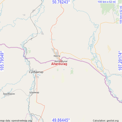
Altanbulag GPS coordinates[2]
50° 18' 56.016" North, 106° 29' 54.996" East
| Map corner | latitude | longitude |
|---|---|---|
| Upper-left | 50.76243°, | 105.79549° |
| Center: | 50.31556°, | 106.49861° |
| Lower-right: | 49.86445°, | 107.20174° |
| Map W x H: | 99.8×99.8 km | = 62×62mi |
| max Lat: | 51.50725° ⇑3.1% North |
| Altanbulag: | 50.31556° |
| min Lat: | ⇓96.9% South 42.84199° |
| min Long | Altanbulag | max Long |
| 89.14358° | 106.49861° | 118.51014° |
| W 74.8%⇐ | ⇒25.2% E |
Elevation
Elevation of Altanbulag is 698 m = 2290 ft, and this is 718.5 m = 2357 ft below average elevation for this country.
| Max E: |
2800 m = 9186 ft | 97.5% |
| Avg. | 1416.5 m = 4647 ft | |
| Altanbulag | 698 m = 2290 ft | |
Min E: |
619 m = 2031 ft | 2.5% |
See also: Mongolia elevation on elevation.city.
Geographical zone
Altanbulag is located in North temperate zone (between Tropic of Cancer and the Arctic Circle). Distance of this North polar circle is 1806.6 km =1122.6 mi to North.| Distance of | km | miles | from Altanbulag |
|---|---|---|---|
| North Pole | 4412.5 | 2741.8 | to North |
| Arctic Circle | 1806.6 | 1122.6 | to North |
| Tropic Cancer | 2988.6 | 1857 | to South |
| Equator | 5594.6 | 3476.3 | to South |


Nearby cities:
15 places around Altanbulag: (largest is in red/bold)
• Bugant
85.2 km =52.9 mi,  162°
162°
• Bulagtay
94.2 km =58.5 mi,  129°
129°
• Darhan
101 km =62.8 mi,  204°
204°
• Delgerhaan
33.9 km =21.1 mi,  221°
221°
• Dzelter
103.1 km =64.1 mi,  270°
270°
• Enhtal
143.6 km =89.2 mi,  214°
214°
• Hongor
128.2 km =79.7 mi, 199°
• Hushaat
110.5 km =68.7 mi, 214°
• Huurch
80.3 km =49.9 mi,  252°
252°
• Jargalant
51.9 km =32.2 mi,  237°
237°
• Nart
152.7 km =94.9 mi, 211°
• Nomgon
137.7 km =85.6 mi, 205°
• Orhon
59.6 km =37 mi, 205°
• Sharïngol
120 km =74.6 mi,  182°
182°
• Sühbaatar
22.7 km =14.1 mi, 245°
Sources, notices
• [Note1] Compared only with cities in Mongolia existing in our database
• [Src1] Map data: © OpenStreetMap contributors (CC-BY-SA)
• [Src2] Other city data from geonames.org with taken over terms of usage.
• [Src3] Geographical zone / Annual Mean Temperature by Robert A. Rohde @ Wikipedia
