Ovoot geodata
Ovoot (Sühbaatar) is a seat of a second-order administrative division; located in Mongolia in Asia/Choibalsan (GMT+8) time zone. In our database, there are 33 cities with bigger population. Compared to other cities in Mongolia, 88.3% of cities are located further ↑North; 96.3% of cities are located further ←West and 64.4% of cities have higher elevation than Ovoot. Note1


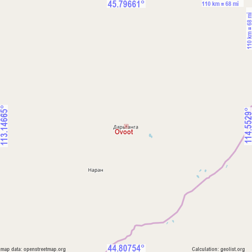
Ovoot GPS coordinates[2]
45° 18' 15.228" North, 113° 50' 59.172" East
| Map corner | latitude | longitude |
|---|---|---|
| Upper-left | 45.79661°, | 113.14665° |
| Center: | 45.30423°, | 113.84977° |
| Lower-right: | 44.80754°, | 114.5529° |
| Map W x H: | 110×110 km | = 68.4×68.4mi |
| max Lat: | 51.50725° ⇑88.3% North |
| Ovoot: | 45.30423° |
| min Lat: | ⇓11.7% South 42.84199° |
| min Long | Ovoot | max Long |
| 89.14358° | 113.84977° | 118.51014° |
| W 96.3%⇐ | ⇒3.7% E |
Elevation
Elevation of Ovoot is 1244 m = 4081 ft, and this is 172.5 m = 566 ft below average elevation for this country.
| Max E: |
2800 m = 9186 ft | 64.4% |
| Avg. | 1416.5 m = 4647 ft | |
| Ovoot | 1244 m = 4081 ft | |
Min E: |
619 m = 2031 ft | 35.6% |
See also: Mongolia elevation on elevation.city.
Geographical zone
Ovoot is located in North temperate zone (between Tropic of Cancer and the Arctic Circle). Distance of this North polar circle is 2363.8 km =1468.8 mi to North.| Distance of | km | miles | from Ovoot |
|---|---|---|---|
| North Pole | 4969.7 | 3088 | to North |
| Arctic Circle | 2363.8 | 1468.8 | to North |
| Tropic Cancer | 2431.4 | 1510.8 | to South |
| Equator | 5037.4 | 3130.1 | to South |


Nearby cities:
15 places around Ovoot: (largest is in red/bold)
• Baruun-Urt
159.3 km =99 mi,  343°
343°
• Bayasgalant
232.5 km =144.5 mi,  323°
323°
• Chonogol
135.3 km =84.1 mi,  60°
60°
• Dzüünbulag
176.2 km =109.5 mi,  312°
312°
• Dzüünbulag
214.5 km =133.3 mi,  31°
31°
• Hatavch
118.6 km =73.7 mi, 323°
• Havirga
72.1 km =44.8 mi,  303°
303°
• Haylaastay
163.1 km =101.3 mi,  0°
0°
• Hongor
22.9 km =14.2 mi,  214°
214°
• Hongor
213.5 km =132.7 mi,  284°
284°
• Senj
251 km =156 mi,  254°
254°
• Sergelen
186.5 km =115.9 mi, 302°
• Shireet
125.6 km =78 mi,  292°
292°
• Ulaan-Uul
232.9 km =144.7 mi,  242°
242°
• Ulaandel
119.8 km =74.4 mi,  349°
349°
Sources, notices
• [Note1] Compared only with cities in Mongolia existing in our database
• [Src1] Map data: © OpenStreetMap contributors (CC-BY-SA)
• [Src2] Other city data from geonames.org with taken over terms of usage.
• [Src3] Geographical zone / Annual Mean Temperature by Robert A. Rohde @ Wikipedia
