Hatavch geodata
Hatavch (Sühbaatar) is a seat of a second-order administrative division; located in Mongolia in Asia/Choibalsan (GMT+8) time zone. In our database, there are 33 cities with bigger population. Compared to other cities in Mongolia, 77% of cities are located further ↑North; 93.9% of cities are located further ←West and 80.4% of cities have higher elevation than Hatavch. Note1


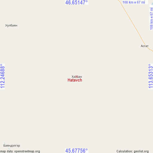
Hatavch GPS coordinates[2]
46° 10' 0.012" North, 112° 57' 0" East
| Map corner | latitude | longitude |
|---|---|---|
| Upper-left | 46.65147°, | 112.24688° |
| Center: | 46.16667°, | 112.95° |
| Lower-right: | 45.67756°, | 113.65313° |
| Map W x H: | 108.3×108.3 km | = 67.3×67.3mi |
| max Lat: | 51.50725° ⇑77% North |
| Hatavch: | 46.16667° |
| min Lat: | ⇓23% South 42.84199° |
| min Long | Hatavch | max Long |
| 89.14358° | 112.95° | 118.51014° |
| W 93.9%⇐ | ⇒6.1% E |
Elevation
Elevation of Hatavch is 1047 m = 3435 ft, and this is 369.5 m = 1212 ft below average elevation for this country.
| Max E: |
2800 m = 9186 ft | 80.4% |
| Avg. | 1416.5 m = 4647 ft | |
| Hatavch | 1047 m = 3435 ft | |
Min E: |
619 m = 2031 ft | 19.6% |
See also: Mongolia elevation on elevation.city.
Geographical zone
Hatavch is located in North temperate zone (between Tropic of Cancer and the Arctic Circle). Distance of this North polar circle is 2267.9 km =1409.2 mi to North.| Distance of | km | miles | from Hatavch |
|---|---|---|---|
| North Pole | 4873.8 | 3028.4 | to North |
| Arctic Circle | 2267.9 | 1409.2 | to North |
| Tropic Cancer | 2527.3 | 1570.4 | to South |
| Equator | 5133.3 | 3189.7 | to South |


Nearby cities:
15 places around Hatavch: (largest is in red/bold)
• Baruun-Urt
62.5 km =38.8 mi,  23°
23°
• Bayasgalant
113.9 km =70.8 mi,  322°
322°
• Buyant
163.1 km =101.3 mi,  273°
273°
• Chonogol
188.9 km =117.4 mi,  99°
99°
• Dzüünbulag
63.7 km =39.6 mi,  292°
292°
• Hanhöhiy
172.8 km =107.4 mi,  338°
338°
• Havirga
56.5 km =35.1 mi,  169°
169°
• Haylaastay
98 km =60.9 mi,  46°
46°
• Hongor
128.1 km =79.6 mi,  153°
153°
• Hongor
141.2 km =87.7 mi,  253°
253°
• Javhlant
190.5 km =118.4 mi, 340°
• Ovoot
118.6 km =73.7 mi,  143°
143°
• Sergelen
87.3 km =54.2 mi, 272°
• Shireet
67.1 km =41.7 mi,  223°
223°
• Ulaandel
53 km =32.9 mi,  65°
65°
Sources, notices
• [Note1] Compared only with cities in Mongolia existing in our database
• [Src1] Map data: © OpenStreetMap contributors (CC-BY-SA)
• [Src2] Other city data from geonames.org with taken over terms of usage.
• [Src3] Geographical zone / Annual Mean Temperature by Robert A. Rohde @ Wikipedia
