Mandal geodata
Mandal (Bulgan) is a seat of a second-order administrative division; located in Mongolia in Asia/Ulaanbaatar (GMT+8) time zone. In our database, there are 33 cities with bigger population. Compared to other cities in Mongolia, 69.6% of cities are located further ↓South; 54.9% of cities are located further ←West and 78.2% of cities have higher elevation than Mandal. Note1


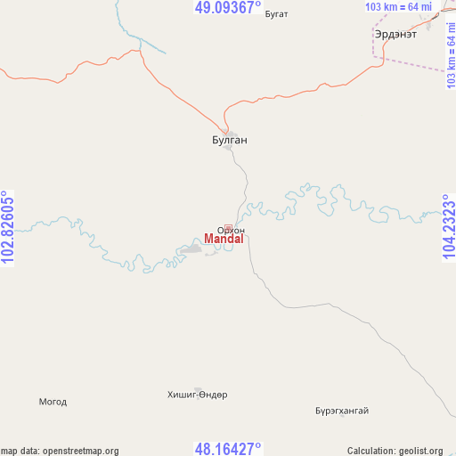
Mandal GPS coordinates[2]
48° 37' 51.996" North, 103° 31' 45.012" East
| Map corner | latitude | longitude |
|---|---|---|
| Upper-left | 49.09367°, | 102.82605° |
| Center: | 48.63111°, | 103.52917° |
| Lower-right: | 48.16427°, | 104.2323° |
| Map W x H: | 103.3×103.3 km | = 64.2×64.2mi |
| max Lat: | 51.50725° ⇑30.4% North |
| Mandal: | 48.63111° |
| min Lat: | ⇓69.6% South 42.84199° |
| min Long | Mandal | max Long |
| 89.14358° | 103.52917° | 118.51014° |
| W 54.9%⇐ | ⇒45.1% E |
Elevation
Elevation of Mandal is 1074 m = 3524 ft, and this is 342.5 m = 1124 ft below average elevation for this country.
| Max E: |
2800 m = 9186 ft | 78.2% |
| Avg. | 1416.5 m = 4647 ft | |
| Mandal | 1074 m = 3524 ft | |
Min E: |
619 m = 2031 ft | 21.8% |
See also: Mongolia elevation on elevation.city.
Geographical zone
Mandal is located in North temperate zone (between Tropic of Cancer and the Arctic Circle). Distance of this North polar circle is 1993.9 km =1239 mi to North.| Distance of | km | miles | from Mandal |
|---|---|---|---|
| North Pole | 4599.8 | 2858.2 | to North |
| Arctic Circle | 1993.9 | 1239 | to North |
| Tropic Cancer | 2801.4 | 1740.7 | to South |
| Equator | 5407.3 | 3359.9 | to South |


Nearby cities:
15 places around Mandal: (largest is in red/bold)
• Avdzaga
110.9 km =68.9 mi,  180°
180°
• Bat-Öldziyt
102.8 km =63.9 mi,  116°
116°
• Bugat
49.5 km =30.8 mi,  11°
11°
• Bulgan
20.2 km =12.6 mi,  1°
1°
• Darhan
49.2 km =30.6 mi,  148°
148°
• Dashinchilling
95 km =59 mi,  156°
156°
• Erdenet
60.4 km =37.5 mi,  42°
42°
• Erhet
56.7 km =35.2 mi,  225°
225°
• Hutag
104.5 km =64.9 mi,  324°
324°
• Höshööt
92.9 km =57.7 mi, 230°
• Hüremt
66.7 km =41.4 mi,  273°
273°
• Ingettolgoy
97.9 km =60.8 mi,  19°
19°
• Jargalant
84.8 km =52.7 mi,  49°
49°
• Maanĭt
38 km =23.6 mi,  191°
191°
• Sört
98.5 km =61.2 mi, 39°
Sources, notices
• [Note1] Compared only with cities in Mongolia existing in our database
• [Src1] Map data: © OpenStreetMap contributors (CC-BY-SA)
• [Src2] Other city data from geonames.org with taken over terms of usage.
• [Src3] Geographical zone / Annual Mean Temperature by Robert A. Rohde @ Wikipedia
