Makata geodata
Makata (Southern Region) is a seat of a third-order administrative division; located in Malawi in Africa/Blantyre (GMT+2) time zone. In our database, there are 33 cities with bigger population. Compared to other cities in Malawi, 82.9% of cities are located further ↑North; 71.4% of cities are located further ←West and 68.6% of cities have lower elevation than Makata. Note1


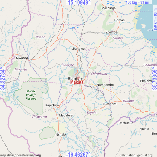
Makata GPS coordinates[2]
15° 47' 13.956" South, 35° 1' 49.656" East
| Map corner | latitude | longitude |
|---|---|---|
| Upper-left | -15.10949°, | 34.32734° |
| Center: | -15.78721°, | 35.03046° |
| Lower-right: | -16.46267°, | 35.73359° |
| Map W x H: | 150.5×150.5 km | = 93.5×93.5mi |
| max Lat: | -9.70237° ⇑82.9% North |
| Makata: | -15.78721° |
| min Lat: | ⇓17.1% South -16.91995° |
| min Long | Makata | max Long |
| 32.88019° | 35.03046° | 35.65067° |
| W 71.4%⇐ | ⇒28.6% E |
Elevation
Elevation of Makata is 1085 m = 3560 ft, and this is 216.3 m = 710 ft above average elevation for this country.
| Max E: |
1608 m = 5276 ft | 31.4% |
| Makata | 1085 m 3560 ft | |
| Avg. | 868.7 m = 2850 ft | |
Min E: |
55 m = 180 ft | 68.6% |
See also: Malawi elevation on elevation.city.
Geographical zone
Makata is located in South Torrid zone (between Equator and Tropic of Capricorn). Distance of this Southern Tropic circle is 850.5 km =528.5 mi to South.| Distance of | km | miles | from Makata |
|---|---|---|---|
| Equator | 1755.4 | 1090.8 | to North |
| Tropic Capricorn | 850.5 | 528.5 | to South |
| Antarctic Circle | 5645.8 | 3508.1 | to South |
| South Pole | 8251.7 | 5127.4 | to South |


Nearby cities:
15 places around Makata: (largest is in red/bold)
• Balaka
90.2 km =56 mi,  354°
354°
• Blantyre
2.4 km =1.5 mi,  276°
276°
• Chikwawa
36.8 km =22.9 mi,  221°
221°
• Chiradzulu
17.2 km =10.7 mi,  43°
43°
• Liwonde
82.8 km =51.4 mi,  14°
14°
• Luchenza
38.6 km =24 mi,  129°
129°
• Machinga
74.6 km =46.4 mi,  22°
22°
• Mulanje
57.1 km =35.5 mi,  118°
118°
• Mwanza
57.9 km =36 mi,  290°
290°
• Neno
59.2 km =36.8 mi,  316°
316°
• Nsanje
128.3 km =79.7 mi,  168°
168°
• Ntcheu
115.5 km =71.8 mi,  338°
338°
• Phalombe
66.4 km =41.3 mi,  91°
91°
• Thyolo
33.3 km =20.7 mi,  159°
159°
• Zomba
54.3 km =33.7 mi,  34°
34°
Sources, notices
• [Note1] Compared only with cities in Malawi existing in our database
• [Src1] Map data: © OpenStreetMap contributors (CC-BY-SA)
• [Src2] Other city data from geonames.org with taken over terms of usage.
• [Src3] Geographical zone / Annual Mean Temperature by Robert A. Rohde @ Wikipedia
