Ntcheu geodata
Ntcheu (Central Region) is a seat of a second-order administrative division; located in Malawi in Africa/Blantyre (GMT+2) time zone. With population of 10,445 people, there are 22 cities with bigger population in this country. Compared to other cities in Malawi, 57.1% of cities are located further ↑North; 51.4% of cities are located further ←West and 74.3% of cities have lower elevation than Ntcheu. Note1


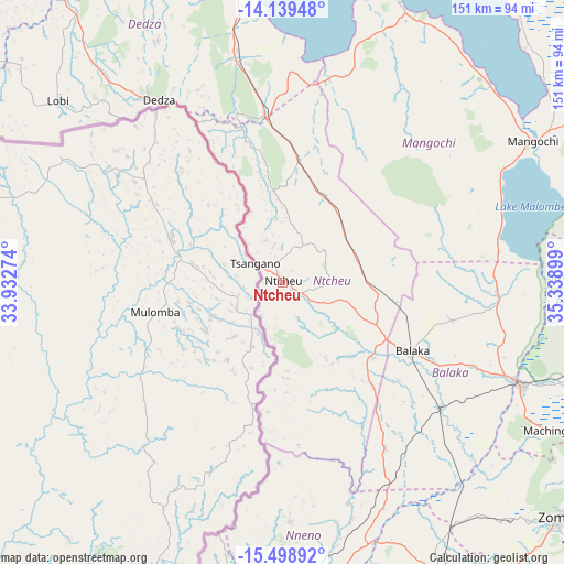
Ntcheu GPS coordinates[2]
14° 49' 12.972" South, 34° 38' 9.096" East
| Map corner | latitude | longitude |
|---|---|---|
| Upper-left | -14.13948°, | 33.93274° |
| Center: | -14.82027°, | 34.63586° |
| Lower-right: | -15.49892°, | 35.33899° |
| Map W x H: | 151.2×151.2 km | = 94×94mi |
| max Lat: | -9.70237° ⇑57.1% North |
| Ntcheu: | -14.82027° |
| min Lat: | ⇓42.9% South -16.91995° |
| min Long | Ntcheu | max Long |
| 32.88019° | 34.63586° | 35.65067° |
| W 51.4%⇐ | ⇒48.6% E |
Elevation
Elevation of Ntcheu is 1132 m = 3714 ft, and this is 263.3 m = 864 ft above average elevation for this country.
| Max E: |
1608 m = 5276 ft | 25.7% |
| Ntcheu | 1132 m 3714 ft | |
| Avg. | 868.7 m = 2850 ft | |
Min E: |
55 m = 180 ft | 74.3% |
See also: Malawi elevation on elevation.city.
Geographical zone
Ntcheu is located in South Torrid zone (between Equator and Tropic of Capricorn). Distance of this Southern Tropic circle is 958.1 km =595.3 mi to South.| Distance of | km | miles | from Ntcheu |
|---|---|---|---|
| Equator | 1647.9 | 1024 | to North |
| Tropic Capricorn | 958.1 | 595.3 | to South |
| Antarctic Circle | 5753.3 | 3574.9 | to South |
| South Pole | 8359.2 | 5194.2 | to South |


Nearby cities:
15 places around Ntcheu: (largest is in red/bold)
• Balaka
38.7 km =24 mi,  117°
117°
• Blantyre
114.5 km =71.1 mi,  159°
159°
• Chipoka
92.9 km =57.7 mi,  351°
351°
• Chiradzulu
109.3 km =67.9 mi,  150°
150°
• Dedza
59 km =36.7 mi,  326°
326°
• Lilongwe
131.7 km =81.8 mi,  316°
316°
• Liwonde
69 km =42.9 mi,  113°
113°
• Machinga
81.2 km =50.5 mi, 118°
• Makata
115.5 km =71.8 mi, 158°
• Mangochi
77.6 km =48.2 mi,  60°
60°
• Monkey Bay
87.4 km =54.3 mi,  20°
20°
• Mwanza
87.8 km =54.6 mi,  187°
187°
• Neno
64.3 km =40 mi,  178°
178°
• Salima
117.2 km =72.8 mi, 350°
• Zomba
96.6 km =60 mi,  130°
130°
Sources, notices
• [Note1] Compared only with cities in Malawi existing in our database
• [Src1] Map data: © OpenStreetMap contributors (CC-BY-SA)
• [Src2] Other city data from geonames.org with taken over terms of usage.
• [Src3] Geographical zone / Annual Mean Temperature by Robert A. Rohde @ Wikipedia
