Balaka geodata
Balaka (Southern Region) is a seat of a second-order administrative division; located in Malawi in Africa/Blantyre (GMT+2) time zone. With population of 18,902 people, there are 13 cities with bigger population in this country. Compared to other cities in Malawi, 60% of cities are located further ↑North; 65.7% of cities are located further ←West and 65.7% of cities have higher elevation than Balaka. Note1


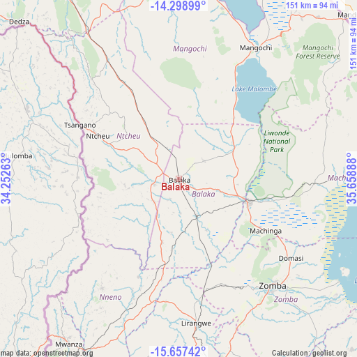
Balaka GPS coordinates[2]
14° 58' 45.408" South, 34° 57' 20.7" East
| Map corner | latitude | longitude |
|---|---|---|
| Upper-left | -14.29899°, | 34.25263° |
| Center: | -14.97928°, | 34.95575° |
| Lower-right: | -15.65742°, | 35.65888° |
| Map W x H: | 151×151 km | = 93.8×93.8mi |
| max Lat: | -9.70237° ⇑60% North |
| Balaka: | -14.97928° |
| min Lat: | ⇓40% South -16.91995° |
| min Long | Balaka | max Long |
| 32.88019° | 34.95575° | 35.65067° |
| W 65.7%⇐ | ⇒34.3% E |
Elevation
Elevation of Balaka is 633 m = 2077 ft, and this is 235.7 m = 773 ft below average elevation for this country.
| Max E: |
1608 m = 5276 ft | 65.7% |
| Avg. | 868.7 m = 2850 ft | |
| Balaka | 633 m = 2077 ft | |
Min E: |
55 m = 180 ft | 34.3% |
See also: Malawi elevation on elevation.city.
Geographical zone
Balaka is located in South Torrid zone (between Equator and Tropic of Capricorn). Distance of this Southern Tropic circle is 940.4 km =584.3 mi to South.| Distance of | km | miles | from Balaka |
|---|---|---|---|
| Equator | 1665.5 | 1034.9 | to North |
| Tropic Capricorn | 940.4 | 584.3 | to South |
| Antarctic Circle | 5735.6 | 3563.9 | to South |
| South Pole | 8341.5 | 5183.2 | to South |


Nearby cities:
15 places around Balaka: (largest is in red/bold)
• Blantyre
89.8 km =55.8 mi,  176°
176°
• Chikwawa
118.4 km =73.6 mi,  188°
188°
• Chipoka
119.4 km =74.2 mi,  336°
336°
• Chiradzulu
79.8 km =49.6 mi,  165°
165°
• Dedza
94.6 km =58.8 mi,  314°
314°
• Liwonde
30.5 km =19 mi,  108°
108°
• Machinga
42.5 km =26.4 mi,  119°
119°
• Makata
90.2 km =56 mi, 174°
• Mangochi
64.9 km =40.3 mi,  30°
30°
• Monkey Bay
99.8 km =62 mi,  357°
357°
• Mwanza
83.3 km =51.8 mi,  213°
213°
• Neno
56.7 km =35.2 mi, 214°
• Ntcheu
38.7 km =24 mi,  297°
297°
• Phalombe
118.3 km =73.5 mi,  140°
140°
• Zomba
59.7 km =37.1 mi, 139°
Sources, notices
• [Note1] Compared only with cities in Malawi existing in our database
• [Src1] Map data: © OpenStreetMap contributors (CC-BY-SA)
• [Src2] Other city data from geonames.org with taken over terms of usage.
• [Src3] Geographical zone / Annual Mean Temperature by Robert A. Rohde @ Wikipedia
