Neno geodata
Neno (Southern Region) is a seat of a second-order administrative division; located in Malawi in Africa/Blantyre (GMT+2) time zone. In our database, there are 33 cities with bigger population. Compared to other cities in Malawi, 71.4% of cities are located further ↑North; 54.3% of cities are located further ←West and 51.4% of cities have higher elevation than Neno. Note1


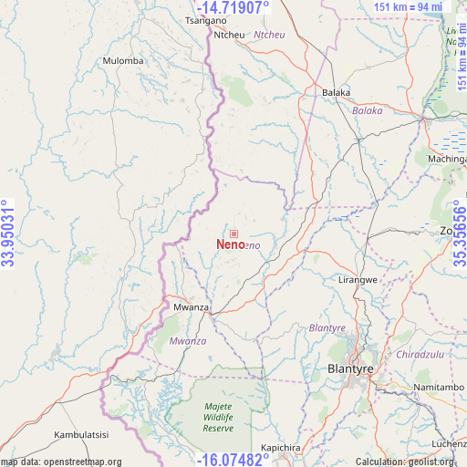
Neno GPS coordinates[2]
15° 23' 52.98" South, 34° 39' 12.348" East
| Map corner | latitude | longitude |
|---|---|---|
| Upper-left | -14.71907°, | 33.95031° |
| Center: | -15.39805°, | 34.65343° |
| Lower-right: | -16.07482°, | 35.35656° |
| Map W x H: | 150.7×150.7 km | = 93.6×93.6mi |
| max Lat: | -9.70237° ⇑71.4% North |
| Neno: | -15.39805° |
| min Lat: | ⇓28.6% South -16.91995° |
| min Long | Neno | max Long |
| 32.88019° | 34.65343° | 35.65067° |
| W 54.3%⇐ | ⇒45.7% E |
Elevation
Elevation of Neno is 907 m = 2976 ft, and this is 38.3 m = 126 ft above average elevation for this country.
| Max E: |
1608 m = 5276 ft | 51.4% |
| Neno | 907 m 2976 ft | |
| Avg. | 868.7 m = 2850 ft | |
Min E: |
55 m = 180 ft | 48.6% |
See also: Malawi elevation on elevation.city.
Geographical zone
Neno is located in South Torrid zone (between Equator and Tropic of Capricorn). Distance of this Southern Tropic circle is 893.8 km =555.4 mi to South.| Distance of | km | miles | from Neno |
|---|---|---|---|
| Equator | 1712.1 | 1063.8 | to North |
| Tropic Capricorn | 893.8 | 555.4 | to South |
| Antarctic Circle | 5689.1 | 3535 | to South |
| South Pole | 8295 | 5154.3 | to South |


Nearby cities:
15 places around Neno: (largest is in red/bold)
• Balaka
56.7 km =35.2 mi,  34°
34°
• Blantyre
57.4 km =35.7 mi,  138°
138°
• Chikwawa
72.4 km =45 mi,  167°
167°
• Chiradzulu
60.6 km =37.7 mi,  120°
120°
• Dedza
118.5 km =73.6 mi,  343°
343°
• Liwonde
71.6 km =44.5 mi,  59°
59°
• Luchenza
97.5 km =60.6 mi,  133°
133°
• Machinga
73.9 km =45.9 mi,  69°
69°
• Makata
59.2 km =36.8 mi, 136°
• Mulanje
114.8 km =71.3 mi, 127°
• Mwanza
26.6 km =16.5 mi,  211°
211°
• Ntcheu
64.3 km =40 mi,  358°
358°
• Phalombe
116 km =72.1 mi,  113°
113°
• Thyolo
90.9 km =56.5 mi,  145°
145°
• Zomba
71.3 km =44.3 mi,  88°
88°
Sources, notices
• [Note1] Compared only with cities in Malawi existing in our database
• [Src1] Map data: © OpenStreetMap contributors (CC-BY-SA)
• [Src2] Other city data from geonames.org with taken over terms of usage.
• [Src3] Geographical zone / Annual Mean Temperature by Robert A. Rohde @ Wikipedia
