Chiradzulu geodata
Chiradzulu (Southern Region) is a seat of a second-order administrative division; located in Malawi in Africa/Blantyre (GMT+2) time zone. With population of 1,580 people, there are 31 cities with bigger population in this country. Compared to other cities in Malawi, 77.1% of cities are located further ↑North; 77.1% of cities are located further ←West and 71.4% of cities have lower elevation than Chiradzulu. Note1


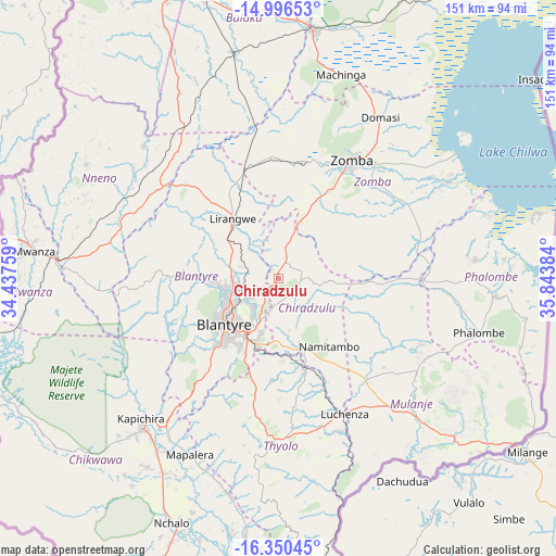
Chiradzulu GPS coordinates[2]
15° 40' 28.596" South, 35° 8' 26.556" East
| Map corner | latitude | longitude |
|---|---|---|
| Upper-left | -14.99653°, | 34.43759° |
| Center: | -15.67461°, | 35.14071° |
| Lower-right: | -16.35045°, | 35.84384° |
| Map W x H: | 150.5×150.5 km | = 93.5×93.5mi |
| max Lat: | -9.70237° ⇑77.1% North |
| Chiradzulu: | -15.67461° |
| min Lat: | ⇓22.9% South -16.91995° |
| min Long | Chiradzulu | max Long |
| 32.88019° | 35.14071° | 35.65067° |
| W 77.1%⇐ | ⇒22.9% E |
Elevation
Elevation of Chiradzulu is 1118 m = 3668 ft, and this is 249.3 m = 818 ft above average elevation for this country.
| Max E: |
1608 m = 5276 ft | 28.6% |
| Chiradzulu | 1118 m 3668 ft | |
| Avg. | 868.7 m = 2850 ft | |
Min E: |
55 m = 180 ft | 71.4% |
See also: Malawi elevation on elevation.city.
Geographical zone
Chiradzulu is located in South Torrid zone (between Equator and Tropic of Capricorn). Distance of this Southern Tropic circle is 863.1 km =536.3 mi to South.| Distance of | km | miles | from Chiradzulu |
|---|---|---|---|
| Equator | 1742.9 | 1083 | to North |
| Tropic Capricorn | 863.1 | 536.3 | to South |
| Antarctic Circle | 5658.3 | 3515.9 | to South |
| South Pole | 8264.2 | 5135.1 | to South |


Nearby cities:
15 places around Chiradzulu: (largest is in red/bold)
• Balaka
79.8 km =49.6 mi,  345°
345°
• Blantyre
18.7 km =11.6 mi,  229°
229°
• Chikwawa
54 km =33.6 mi,  222°
222°
• Liwonde
68.2 km =42.4 mi,  7°
7°
• Luchenza
41.1 km =25.5 mi,  153°
153°
• Machinga
58.8 km =36.5 mi,  16°
16°
• Makata
17.2 km =10.7 mi, 223°
• Mangochi
133.7 km =83.1 mi, 5°
• Mulanje
55.3 km =34.4 mi,  135°
135°
• Mwanza
66.4 km =41.3 mi,  276°
276°
• Neno
60.6 km =37.7 mi,  300°
300°
• Ntcheu
109.3 km =67.9 mi,  330°
330°
• Phalombe
56.5 km =35.1 mi,  105°
105°
• Thyolo
43.7 km =27.2 mi,  180°
180°
• Zomba
37.3 km =23.2 mi,  30°
30°
Sources, notices
• [Note1] Compared only with cities in Malawi existing in our database
• [Src1] Map data: © OpenStreetMap contributors (CC-BY-SA)
• [Src2] Other city data from geonames.org with taken over terms of usage.
• [Src3] Geographical zone / Annual Mean Temperature by Robert A. Rohde @ Wikipedia
