Chikwawa geodata
Chikwawa (Southern Region) is a seat of a second-order administrative division; located in Malawi in Africa/Blantyre (GMT+2) time zone. With population of 6,987 people, there are 25 cities with bigger population in this country. Compared to other cities in Malawi, 94.3% of cities are located further ↑North; 60% of cities are located further ←West and 97.1% of cities have higher elevation than Chikwawa. Note1


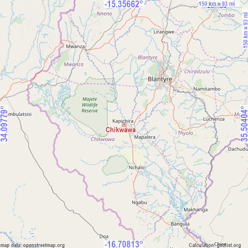
Chikwawa GPS coordinates[2]
16° 2' 0.672" South, 34° 48' 3.276" East
| Map corner | latitude | longitude |
|---|---|---|
| Upper-left | -15.35662°, | 34.09779° |
| Center: | -16.03352°, | 34.80091° |
| Lower-right: | -16.70813°, | 35.50404° |
| Map W x H: | 150.3×150.3 km | = 93.4×93.4mi |
| max Lat: | -9.70237° ⇑94.3% North |
| Chikwawa: | -16.03352° |
| min Lat: | ⇓5.7% South -16.91995° |
| min Long | Chikwawa | max Long |
| 32.88019° | 34.80091° | 35.65067° |
| W 60%⇐ | ⇒40% E |
Elevation
Elevation of Chikwawa is 106 m = 348 ft, and this is 762.7 m = 2502 ft below average elevation for this country.
| Max E: |
1608 m = 5276 ft | 97.1% |
| Avg. | 868.7 m = 2850 ft | |
| Chikwawa | 106 m = 348 ft | |
Min E: |
55 m = 180 ft | 2.9% |
See also: Malawi elevation on elevation.city.
Geographical zone
Chikwawa is located in South Torrid zone (between Equator and Tropic of Capricorn). Distance of this Southern Tropic circle is 823.2 km =511.5 mi to South.| Distance of | km | miles | from Chikwawa |
|---|---|---|---|
| Equator | 1782.8 | 1107.8 | to North |
| Tropic Capricorn | 823.2 | 511.5 | to South |
| Antarctic Circle | 5618.4 | 3491.1 | to South |
| South Pole | 8224.3 | 5110.3 | to South |


Nearby cities:
15 places around Chikwawa: (largest is in red/bold)
• Balaka
118.4 km =73.6 mi,  8°
8°
• Blantyre
35.4 km =22 mi,  38°
38°
• Chiradzulu
54 km =33.6 mi, 42°
• Liwonde
116.7 km =72.5 mi,  22°
22°
• Luchenza
54.4 km =33.8 mi,  86°
86°
• Machinga
110 km =68.4 mi,  29°
29°
• Makata
36.8 km =22.9 mi, 41°
• Mulanje
74.7 km =46.4 mi, 89°
• Mwanza
56.3 km =35 mi,  328°
328°
• Neno
72.4 km =45 mi,  347°
347°
• Nsanje
110.1 km =68.4 mi,  153°
153°
• Ntcheu
136.1 km =84.6 mi, 352°
• Phalombe
94.3 km =58.6 mi,  74°
74°
• Thyolo
36.5 km =22.7 mi,  95°
95°
• Zomba
90.9 km =56.5 mi, 37°
Sources, notices
• [Note1] Compared only with cities in Malawi existing in our database
• [Src1] Map data: © OpenStreetMap contributors (CC-BY-SA)
• [Src2] Other city data from geonames.org with taken over terms of usage.
• [Src3] Geographical zone / Annual Mean Temperature by Robert A. Rohde @ Wikipedia
