Zomba geodata
Zomba (Southern Region) is a seat of a second-order administrative division; located in Malawi in Africa/Blantyre (GMT+2) time zone. With population of 80,932 people, there are 3 cities with bigger population in this country. Compared to other cities in Malawi, 68.6% of cities are located further ↑North; 94.3% of cities are located further ←West and 54.3% of cities have lower elevation than Zomba. Note1


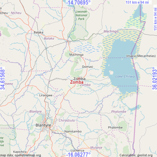
Zomba GPS coordinates[2]
15° 23' 9.456" South, 35° 19' 7.68" East
| Map corner | latitude | longitude |
|---|---|---|
| Upper-left | -14.70695°, | 34.61568° |
| Center: | -15.38596°, | 35.3188° |
| Lower-right: | -16.06277°, | 36.02193° |
| Map W x H: | 150.8×150.8 km | = 93.7×93.7mi |
| max Lat: | -9.70237° ⇑68.6% North |
| Zomba: | -15.38596° |
| min Lat: | ⇓31.4% South -16.91995° |
| min Long | Zomba | max Long |
| 32.88019° | 35.3188° | 35.65067° |
| W 94.3%⇐ | ⇒5.7% E |
Elevation
Elevation of Zomba is 949 m = 3114 ft, and this is 80.3 m = 263 ft above average elevation for this country.
| Max E: |
1608 m = 5276 ft | 45.7% |
| Zomba | 949 m 3114 ft | |
| Avg. | 868.7 m = 2850 ft | |
Min E: |
55 m = 180 ft | 54.3% |
See also: Zomba elevation on elevation.city.
Geographical zone
Zomba is located in South Torrid zone (between Equator and Tropic of Capricorn). Distance of this Southern Tropic circle is 895.2 km =556.3 mi to South.| Distance of | km | miles | from Zomba |
|---|---|---|---|
| Equator | 1710.8 | 1063 | to North |
| Tropic Capricorn | 895.2 | 556.3 | to South |
| Antarctic Circle | 5690.4 | 3535.8 | to South |
| South Pole | 8296.3 | 5155.1 | to South |


Nearby cities:
15 places around Zomba: (largest is in red/bold)
• Balaka
59.7 km =37.1 mi,  319°
319°
• Blantyre
55.4 km =34.4 mi,  216°
216°
• Chikwawa
90.9 km =56.5 mi, 217°
• Chiradzulu
37.3 km =23.2 mi,  210°
210°
• Liwonde
36.9 km =22.9 mi,  344°
344°
• Luchenza
69.1 km =42.9 mi,  180°
180°
• Machinga
24.3 km =15.1 mi,  355°
355°
• Makata
54.3 km =33.7 mi, 214°
• Mangochi
101.1 km =62.8 mi, 356°
• Mulanje
74.4 km =46.2 mi,  164°
164°
• Mwanza
88.4 km =54.9 mi,  254°
254°
• Neno
71.3 km =44.3 mi,  268°
268°
• Ntcheu
96.6 km =60 mi,  310°
310°
• Phalombe
58.7 km =36.5 mi,  142°
142°
• Thyolo
78.2 km =48.6 mi,  194°
194°
Sources, notices
• [Note1] Compared only with cities in Malawi existing in our database
• [Src1] Map data: © OpenStreetMap contributors (CC-BY-SA)
• [Src2] Other city data from geonames.org with taken over terms of usage.
• [Src3] Geographical zone / Annual Mean Temperature by Robert A. Rohde @ Wikipedia
