Machinga geodata
Machinga (Southern Region) is a seat of a second-order administrative division; located in Malawi in Africa/Blantyre (GMT+2) time zone. With population of 1,418 people, there are 32 cities with bigger population in this country. Compared to other cities in Malawi, 65.7% of cities are located further ↑North; 88.6% of cities are located further ←West and 54.3% of cities have higher elevation than Machinga. Note1


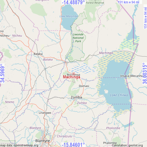
Machinga GPS coordinates[2]
15° 10' 6.564" South, 35° 18' 0.072" East
| Map corner | latitude | longitude |
|---|---|---|
| Upper-left | -14.48879°, | 34.5969° |
| Center: | -15.16849°, | 35.30002° |
| Lower-right: | -15.84601°, | 36.00315° |
| Map W x H: | 150.9×150.9 km | = 93.8×93.8mi |
| max Lat: | -9.70237° ⇑65.7% North |
| Machinga: | -15.16849° |
| min Lat: | ⇓34.3% South -16.91995° |
| min Long | Machinga | max Long |
| 32.88019° | 35.30002° | 35.65067° |
| W 88.6%⇐ | ⇒11.4% E |
Elevation
Elevation of Machinga is 768 m = 2520 ft, and this is 100.7 m = 330 ft below average elevation for this country.
| Max E: |
1608 m = 5276 ft | 54.3% |
| Avg. | 868.7 m = 2850 ft | |
| Machinga | 768 m = 2520 ft | |
Min E: |
55 m = 180 ft | 45.7% |
See also: Malawi elevation on elevation.city.
Geographical zone
Machinga is located in South Torrid zone (between Equator and Tropic of Capricorn). Distance of this Southern Tropic circle is 919.3 km =571.2 mi to South.| Distance of | km | miles | from Machinga |
|---|---|---|---|
| Equator | 1686.6 | 1048 | to North |
| Tropic Capricorn | 919.3 | 571.2 | to South |
| Antarctic Circle | 5714.6 | 3550.9 | to South |
| South Pole | 8320.5 | 5170.1 | to South |


Nearby cities:
15 places around Machinga: (largest is in red/bold)
• Balaka
42.5 km =26.4 mi,  299°
299°
• Blantyre
75.3 km =46.8 mi,  204°
204°
• Chikwawa
110 km =68.4 mi,  209°
209°
• Chiradzulu
58.8 km =36.5 mi, 196°
• Liwonde
13.9 km =8.6 mi,  324°
324°
• Luchenza
93.2 km =57.9 mi,  179°
179°
• Makata
74.6 km =46.4 mi, 202°
• Mangochi
76.9 km =47.8 mi,  357°
357°
• Mulanje
98.3 km =61.1 mi,  167°
167°
• Mwanza
96.1 km =59.7 mi,  239°
239°
• Neno
73.9 km =45.9 mi,  249°
249°
• Ntcheu
81.2 km =50.5 mi, 298°
• Phalombe
80.3 km =49.9 mi,  152°
152°
• Thyolo
101.4 km =63 mi,  189°
189°
• Zomba
24.3 km =15.1 mi, 175°
Sources, notices
• [Note1] Compared only with cities in Malawi existing in our database
• [Src1] Map data: © OpenStreetMap contributors (CC-BY-SA)
• [Src2] Other city data from geonames.org with taken over terms of usage.
• [Src3] Geographical zone / Annual Mean Temperature by Robert A. Rohde @ Wikipedia
