Luchenza geodata
Luchenza (Southern Region) is a populated place; located in Malawi in Africa/Blantyre (GMT+2) time zone. With population of 11,939 people, there are 17 cities with bigger population in this country. Compared to other cities in Malawi, 88.6% of cities are located further ↑North; 91.4% of cities are located further ←West and 60% of cities have higher elevation than Luchenza. Note1


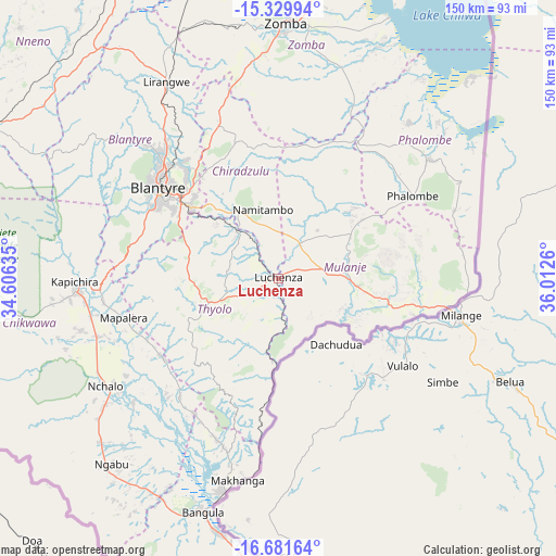
Luchenza GPS coordinates[2]
16° 0' 24.948" South, 35° 18' 34.092" East
| Map corner | latitude | longitude |
|---|---|---|
| Upper-left | -15.32994°, | 34.60635° |
| Center: | -16.00693°, | 35.30947° |
| Lower-right: | -16.68164°, | 36.0126° |
| Map W x H: | 150.3×150.3 km | = 93.4×93.4mi |
| max Lat: | -9.70237° ⇑88.6% North |
| Luchenza: | -16.00693° |
| min Lat: | ⇓11.4% South -16.91995° |
| min Long | Luchenza | max Long |
| 32.88019° | 35.30947° | 35.65067° |
| W 91.4%⇐ | ⇒8.6% E |
Elevation
Elevation of Luchenza is 682 m = 2238 ft, and this is 186.7 m = 613 ft below average elevation for this country.
| Max E: |
1608 m = 5276 ft | 60% |
| Avg. | 868.7 m = 2850 ft | |
| Luchenza | 682 m = 2238 ft | |
Min E: |
55 m = 180 ft | 40% |
See also: Malawi elevation on elevation.city.
Geographical zone
Luchenza is located in South Torrid zone (between Equator and Tropic of Capricorn). Distance of this Southern Tropic circle is 826.1 km =513.3 mi to South.| Distance of | km | miles | from Luchenza |
|---|---|---|---|
| Equator | 1779.8 | 1105.9 | to North |
| Tropic Capricorn | 826.1 | 513.3 | to South |
| Antarctic Circle | 5621.4 | 3493 | to South |
| South Pole | 8227.3 | 5112.2 | to South |


Nearby cities:
15 places around Luchenza: (largest is in red/bold)
• Balaka
120.4 km =74.8 mi,  341°
341°
• Blantyre
40.6 km =25.2 mi,  307°
307°
• Chikwawa
54.4 km =33.8 mi,  266°
266°
• Chiradzulu
41.1 km =25.5 mi,  333°
333°
• Liwonde
104.9 km =65.2 mi,  355°
355°
• Machinga
93.2 km =57.9 mi, 359°
• Makata
38.6 km =24 mi, 309°
• Mulanje
20.5 km =12.7 mi,  97°
97°
• Mwanza
95.2 km =59.2 mi,  298°
298°
• Neno
97.5 km =60.6 mi, 313°
• Nsanje
101.6 km =63.1 mi,  182°
182°
• Ntcheu
150.4 km =93.5 mi, 331°
• Phalombe
42.8 km =26.6 mi,  58°
58°
• Thyolo
19.3 km =12 mi,  249°
249°
• Zomba
69.1 km =42.9 mi,  0°
0°
Sources, notices
• [Note1] Compared only with cities in Malawi existing in our database
• [Src1] Map data: © OpenStreetMap contributors (CC-BY-SA)
• [Src2] Other city data from geonames.org with taken over terms of usage.
• [Src3] Geographical zone / Annual Mean Temperature by Robert A. Rohde @ Wikipedia
