Thyolo geodata
Thyolo (Southern Region) is a seat of a second-order administrative division; located in Malawi in Africa/Blantyre (GMT+2) time zone. With population of 5,775 people, there are 26 cities with bigger population in this country. Compared to other cities in Malawi, 97.1% of cities are located further ↑North; 74.3% of cities are located further ←West and 51.4% of cities have lower elevation than Thyolo. Note1


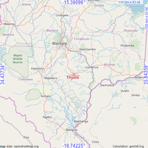
Thyolo GPS coordinates[2]
16° 4' 3.9" South, 35° 8' 25.656" East
| Map corner | latitude | longitude |
|---|---|---|
| Upper-left | -15.39096°, | 34.43734° |
| Center: | -16.06775°, | 35.14046° |
| Lower-right: | -16.74225°, | 35.84359° |
| Map W x H: | 150.2×150.3 km | = 93.3×93.4mi |
| max Lat: | -9.70237° ⇑97.1% North |
| Thyolo: | -16.06775° |
| min Lat: | ⇓2.9% South -16.91995° |
| min Long | Thyolo | max Long |
| 32.88019° | 35.14046° | 35.65067° |
| W 74.3%⇐ | ⇒25.7% E |
Elevation
Elevation of Thyolo is 912 m = 2992 ft, and this is 43.3 m = 142 ft above average elevation for this country.
| Max E: |
1608 m = 5276 ft | 48.6% |
| Thyolo | 912 m 2992 ft | |
| Avg. | 868.7 m = 2850 ft | |
Min E: |
55 m = 180 ft | 51.4% |
See also: Malawi elevation on elevation.city.
Geographical zone
Thyolo is located in South Torrid zone (between Equator and Tropic of Capricorn). Distance of this Southern Tropic circle is 819.4 km =509.2 mi to South.| Distance of | km | miles | from Thyolo |
|---|---|---|---|
| Equator | 1786.6 | 1110.1 | to North |
| Tropic Capricorn | 819.4 | 509.2 | to South |
| Antarctic Circle | 5614.6 | 3488.7 | to South |
| South Pole | 8220.5 | 5108 | to South |


Nearby cities:
15 places around Thyolo: (largest is in red/bold)
• Balaka
122.6 km =76.2 mi,  350°
350°
• Blantyre
34.5 km =21.4 mi,  335°
335°
• Chikwawa
36.5 km =22.7 mi,  275°
275°
• Chiradzulu
43.7 km =27.2 mi,  0°
0°
• Liwonde
111.7 km =69.4 mi, 4°
• Luchenza
19.3 km =12 mi,  69°
69°
• Machinga
101.4 km =63 mi,  9°
9°
• Makata
33.3 km =20.7 mi, 339°
• Mulanje
38.6 km =24 mi,  84°
84°
• Mwanza
83.7 km =52 mi,  308°
308°
• Neno
90.9 km =56.5 mi,  325°
325°
• Nsanje
95.6 km =59.4 mi,  172°
172°
• Ntcheu
148.9 km =92.5 mi, 338°
• Phalombe
61.8 km =38.4 mi,  61°
61°
• Zomba
78.2 km =48.6 mi, 14°
Sources, notices
• [Note1] Compared only with cities in Malawi existing in our database
• [Src1] Map data: © OpenStreetMap contributors (CC-BY-SA)
• [Src2] Other city data from geonames.org with taken over terms of usage.
• [Src3] Geographical zone / Annual Mean Temperature by Robert A. Rohde @ Wikipedia
