Liwonde geodata
Liwonde (Southern Region) is a populated place; located in Malawi in Africa/Blantyre (GMT+2) time zone. With population of 22,469 people, there are 9 cities with bigger population in this country. Compared to other cities in Malawi, 62.9% of cities are located further ↑North; 80% of cities are located further ←West and 80% of cities have higher elevation than Liwonde. Note1


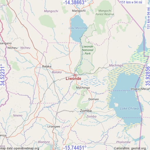
Liwonde GPS coordinates[2]
15° 3' 59.94" South, 35° 13' 31.548" East
| Map corner | latitude | longitude |
|---|---|---|
| Upper-left | -14.38663°, | 34.52231° |
| Center: | -15.06665°, | 35.22543° |
| Lower-right: | -15.74451°, | 35.92856° |
| Map W x H: | 151×151 km | = 93.8×93.8mi |
| max Lat: | -9.70237° ⇑62.9% North |
| Liwonde: | -15.06665° |
| min Lat: | ⇓37.1% South -16.91995° |
| min Long | Liwonde | max Long |
| 32.88019° | 35.22543° | 35.65067° |
| W 80%⇐ | ⇒20% E |
Elevation
Elevation of Liwonde is 499 m = 1637 ft, and this is 369.7 m = 1213 ft below average elevation for this country.
| Max E: |
1608 m = 5276 ft | 80% |
| Avg. | 868.7 m = 2850 ft | |
| Liwonde | 499 m = 1637 ft | |
Min E: |
55 m = 180 ft | 20% |
See also: Malawi elevation on elevation.city.
Geographical zone
Liwonde is located in South Torrid zone (between Equator and Tropic of Capricorn). Distance of this Southern Tropic circle is 930.7 km =578.3 mi to South.| Distance of | km | miles | from Liwonde |
|---|---|---|---|
| Equator | 1675.3 | 1041 | to North |
| Tropic Capricorn | 930.7 | 578.3 | to South |
| Antarctic Circle | 5725.9 | 3557.9 | to South |
| South Pole | 8331.8 | 5177.1 | to South |


Nearby cities:
15 places around Liwonde: (largest is in red/bold)
• Balaka
30.5 km =19 mi,  288°
288°
• Blantyre
83.2 km =51.7 mi,  196°
196°
• Chiradzulu
68.2 km =42.4 mi,  187°
187°
• Luchenza
104.9 km =65.2 mi,  175°
175°
• Machinga
13.9 km =8.6 mi,  144°
144°
• Makata
82.8 km =51.4 mi, 194°
• Mangochi
65.6 km =40.8 mi,  3°
3°
• Monkey Bay
114.4 km =71.1 mi,  343°
343°
• Mulanje
111.3 km =69.2 mi,  164°
164°
• Mwanza
95.9 km =59.6 mi,  231°
231°
• Neno
71.6 km =44.5 mi,  239°
239°
• Ntcheu
69 km =42.9 mi, 293°
• Phalombe
94 km =58.4 mi,  151°
151°
• Thyolo
111.7 km =69.4 mi, 184°
• Zomba
36.9 km =22.9 mi, 164°
Sources, notices
• [Note1] Compared only with cities in Malawi existing in our database
• [Src1] Map data: © OpenStreetMap contributors (CC-BY-SA)
• [Src2] Other city data from geonames.org with taken over terms of usage.
• [Src3] Geographical zone / Annual Mean Temperature by Robert A. Rohde @ Wikipedia
