Nsanje geodata
Nsanje (Southern Region) is a seat of a second-order administrative division; located in Malawi in Africa/Blantyre (GMT+2) time zone. With population of 21,774 people, there are 10 cities with bigger population in this country. Compared to other cities in Malawi, 100% of cities are located further ↑North; 82.9% of cities are located further ←West and 100% of cities have higher elevation than Nsanje. Note1


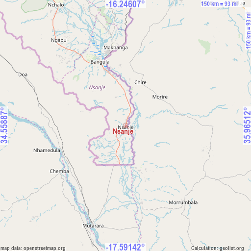
Nsanje GPS coordinates[2]
16° 55' 11.82" South, 35° 15' 43.164" East
| Map corner | latitude | longitude |
|---|---|---|
| Upper-left | -16.24607°, | 34.55887° |
| Center: | -16.91995°, | 35.26199° |
| Lower-right: | -17.59142°, | 35.96512° |
| Map W x H: | 149.6×149.6 km | = 93×93mi |
| max Lat: | -9.70237° ⇑100% North |
| Nsanje: | -16.91995° |
| min Lat: | ⇓0% South -16.91995° |
| min Long | Nsanje | max Long |
| 32.88019° | 35.26199° | 35.65067° |
| W 82.9%⇐ | ⇒17.1% E |
Elevation
Elevation of Nsanje is 55 m = 180 ft, and this is 813.7 m = 2670 ft below average elevation for this country.
| Max E: |
1608 m = 5276 ft | 100% |
| Avg. | 868.7 m = 2850 ft | |
| Nsanje | 55 m = 180 ft | |
Min E: |
55 m = 180 ft | 0% |
See also: Malawi elevation on elevation.city.
Geographical zone
Nsanje is located in South Torrid zone (between Equator and Tropic of Capricorn). Distance of this Southern Tropic circle is 724.6 km =450.2 mi to South.| Distance of | km | miles | from Nsanje |
|---|---|---|---|
| Equator | 1881.3 | 1169 | to North |
| Tropic Capricorn | 724.6 | 450.2 | to South |
| Antarctic Circle | 5519.9 | 3429.9 | to South |
| South Pole | 8125.7 | 5049.1 | to South |


Nearby cities:
15 places around Nsanje: (largest is in red/bold)
• Balaka
218.3 km =135.6 mi,  351°
351°
• Blantyre
129.1 km =80.2 mi, 347°
• Chikwawa
110.1 km =68.4 mi,  333°
333°
• Chiradzulu
139.1 km =86.4 mi, 354°
• Liwonde
206.1 km =128.1 mi,  358°
358°
• Luchenza
101.6 km =63.1 mi,  2°
2°
• Machinga
194.8 km =121 mi, 1°
• Makata
128.3 km =79.7 mi, 348°
• Mulanje
102 km =63.4 mi,  14°
14°
• Mwanza
166.3 km =103.3 mi, 331°
• Neno
181.3 km =112.7 mi,  338°
338°
• Ntcheu
242.9 km =150.9 mi, 343°
• Phalombe
130.6 km =81.2 mi,  18°
18°
• Thyolo
95.6 km =59.4 mi, 352°
• Zomba
170.7 km =106.1 mi, 2°
Sources, notices
• [Note1] Compared only with cities in Malawi existing in our database
• [Src1] Map data: © OpenStreetMap contributors (CC-BY-SA)
• [Src2] Other city data from geonames.org with taken over terms of usage.
• [Src3] Geographical zone / Annual Mean Temperature by Robert A. Rohde @ Wikipedia
