Blantyre geodata
Blantyre (Southern Region) is a seat of a first-order administrative division; located in Malawi in Africa/Blantyre (GMT+2) time zone. With population of 584,877 people, there is 1 city with bigger population in this country. Compared to other cities in Malawi, 80% of cities are located further ↑North; 68.6% of cities are located further ←West and 57.1% of cities have lower elevation than Blantyre. Note1


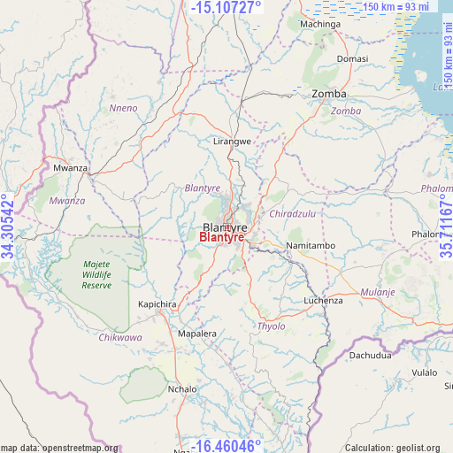
Blantyre GPS coordinates[2]
15° 47' 5.964" South, 35° 0' 30.744" East
| Map corner | latitude | longitude |
|---|---|---|
| Upper-left | -15.10727°, | 34.30542° |
| Center: | -15.78499°, | 35.00854° |
| Lower-right: | -16.46046°, | 35.71167° |
| Map W x H: | 150.5×150.5 km | = 93.5×93.5mi |
| max Lat: | -9.70237° ⇑80% North |
| Blantyre: | -15.78499° |
| min Lat: | ⇓20% South -16.91995° |
| min Long | Blantyre | max Long |
| 32.88019° | 35.00854° | 35.65067° |
| W 68.6%⇐ | ⇒31.4% E |
Elevation
Elevation of Blantyre is 1041 m = 3415 ft, and this is 172.3 m = 565 ft above average elevation for this country.
| Max E: |
1608 m = 5276 ft | 42.9% |
| Blantyre | 1041 m 3415 ft | |
| Avg. | 868.7 m = 2850 ft | |
Min E: |
55 m = 180 ft | 57.1% |
See also: Blantyre elevation on elevation.city.
Geographical zone
Blantyre is located in South Torrid zone (between Equator and Tropic of Capricorn). Distance of this Southern Tropic circle is 850.8 km =528.7 mi to South.| Distance of | km | miles | from Blantyre |
|---|---|---|---|
| Equator | 1755.1 | 1090.6 | to North |
| Tropic Capricorn | 850.8 | 528.7 | to South |
| Antarctic Circle | 5646 | 3508.3 | to South |
| South Pole | 8251.9 | 5127.5 | to South |


Nearby cities:
15 places around Blantyre: (largest is in red/bold)
• Balaka
89.8 km =55.8 mi,  356°
356°
• Chikwawa
35.4 km =22 mi,  218°
218°
• Chiradzulu
18.7 km =11.6 mi,  49°
49°
• Liwonde
83.2 km =51.7 mi,  16°
16°
• Luchenza
40.6 km =25.2 mi,  127°
127°
• Machinga
75.3 km =46.8 mi, 24°
• Makata
2.4 km =1.5 mi,  96°
96°
• Mulanje
59.3 km =36.8 mi,  117°
117°
• Mwanza
55.6 km =34.5 mi,  291°
291°
• Neno
57.4 km =35.7 mi,  318°
318°
• Nsanje
129.1 km =80.2 mi,  167°
167°
• Ntcheu
114.5 km =71.1 mi,  339°
339°
• Phalombe
68.7 km =42.7 mi,  91°
91°
• Thyolo
34.5 km =21.4 mi,  155°
155°
• Zomba
55.4 km =34.4 mi,  36°
36°
Sources, notices
• [Note1] Compared only with cities in Malawi existing in our database
• [Src1] Map data: © OpenStreetMap contributors (CC-BY-SA)
• [Src2] Other city data from geonames.org with taken over terms of usage.
• [Src3] Geographical zone / Annual Mean Temperature by Robert A. Rohde @ Wikipedia
