Mangochi geodata
Mangochi (Southern Region) is a seat of a second-order administrative division; located in Malawi in Africa/Blantyre (GMT+2) time zone. With population of 40,236 people, there are 5 cities with bigger population in this country. Compared to other cities in Malawi, 54.3% of cities are located further ↑North; 85.7% of cities are located further ←West and 91.4% of cities have higher elevation than Mangochi. Note1


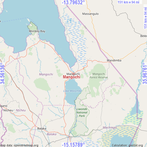
Mangochi GPS coordinates[2]
14° 28' 41.34" South, 35° 15' 52.128" East
| Map corner | latitude | longitude |
|---|---|---|
| Upper-left | -13.79632°, | 34.56136° |
| Center: | -14.47815°, | 35.26448° |
| Lower-right: | -15.15789°, | 35.96761° |
| Map W x H: | 151.4×151.4 km | = 94.1×94.1mi |
| max Lat: | -9.70237° ⇑54.3% North |
| Mangochi: | -14.47815° |
| min Lat: | ⇓45.7% South -16.91995° |
| min Long | Mangochi | max Long |
| 32.88019° | 35.26448° | 35.65067° |
| W 85.7%⇐ | ⇒14.3% E |
Elevation
Elevation of Mangochi is 484 m = 1588 ft, and this is 384.7 m = 1262 ft below average elevation for this country.
| Max E: |
1608 m = 5276 ft | 91.4% |
| Avg. | 868.7 m = 2850 ft | |
| Mangochi | 484 m = 1588 ft | |
Min E: |
55 m = 180 ft | 8.6% |
See also: Mangochi elevation on elevation.city.
Geographical zone
Mangochi is located in South Torrid zone (between Equator and Tropic of Capricorn). Distance of this Southern Tropic circle is 996.1 km =618.9 mi to South.| Distance of | km | miles | from Mangochi |
|---|---|---|---|
| Equator | 1609.8 | 1000.3 | to North |
| Tropic Capricorn | 996.1 | 618.9 | to South |
| Antarctic Circle | 5791.4 | 3598.6 | to South |
| South Pole | 8397.2 | 5217.8 | to South |


Nearby cities:
15 places around Mangochi: (largest is in red/bold)
• Balaka
64.9 km =40.3 mi,  210°
210°
• Blantyre
147.9 km =91.9 mi,  190°
190°
• Chipoka
97.1 km =60.3 mi,  303°
303°
• Chiradzulu
133.7 km =83.1 mi, 185°
• Dedza
100.9 km =62.7 mi,  276°
276°
• Liwonde
65.6 km =40.8 mi,  183°
183°
• Machinga
76.9 km =47.8 mi, 177°
• Makata
147.7 km =91.8 mi, 189°
• Monkey Bay
57.8 km =35.9 mi,  319°
319°
• Mwanza
148.1 km =92 mi, 212°
• Neno
121.5 km =75.5 mi, 212°
• Ntcheu
77.6 km =48.2 mi,  240°
240°
• Phalombe
153.4 km =95.3 mi,  164°
164°
• Salima
116.5 km =72.4 mi,  311°
311°
• Zomba
101.1 km =62.8 mi, 176°
Sources, notices
• [Note1] Compared only with cities in Malawi existing in our database
• [Src1] Map data: © OpenStreetMap contributors (CC-BY-SA)
• [Src2] Other city data from geonames.org with taken over terms of usage.
• [Src3] Geographical zone / Annual Mean Temperature by Robert A. Rohde @ Wikipedia
