Dedza geodata
Dedza (Central Region) is a seat of a second-order administrative division; located in Malawi in Africa/Blantyre (GMT+2) time zone. With population of 15,608 people, there are 16 cities with bigger population in this country. Compared to other cities in Malawi, 51.4% of cities are located further ↑North; 60% of cities are located further →East and 100% of cities have lower elevation than Dedza. Note1


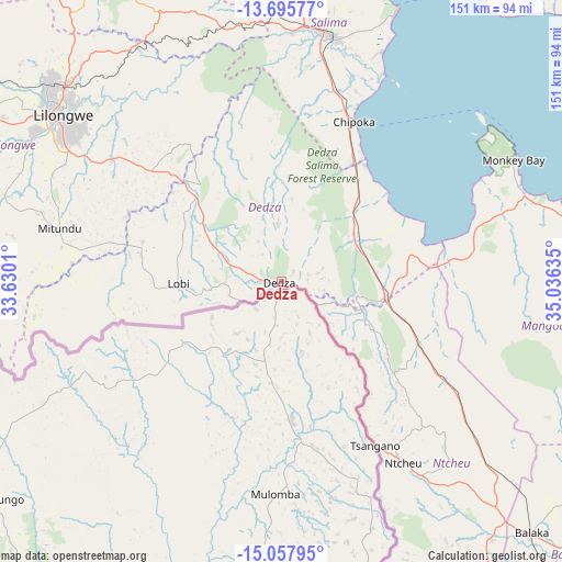
Dedza GPS coordinates[2]
14° 22' 40.44" South, 34° 19' 59.592" East
| Map corner | latitude | longitude |
|---|---|---|
| Upper-left | -13.69577°, | 33.6301° |
| Center: | -14.3779°, | 34.33322° |
| Lower-right: | -15.05795°, | 35.03635° |
| Map W x H: | 151.5×151.5 km | = 94.1×94.1mi |
| max Lat: | -9.70237° ⇑51.4% North |
| Dedza: | -14.3779° |
| min Lat: | ⇓48.6% South -16.91995° |
| min Long | Dedza | max Long |
| 32.88019° | 34.33322° | 35.65067° |
| W 40%⇐ | ⇒60% E |
Elevation
Elevation of Dedza is 1608 m = 5276 ft, and this is 739.3 m = 2426 ft above average elevation for this country.
| Max E: |
1608 m = 5276 ft | 0% |
| Dedza | 1608 m 5276 ft | |
| Avg. | 868.7 m = 2850 ft | |
Min E: |
55 m = 180 ft | 100% |
See also: Malawi elevation on elevation.city.
Geographical zone
Dedza is located in South Torrid zone (between Equator and Tropic of Capricorn). Distance of this Southern Tropic circle is 1007.2 km =625.8 mi to South.| Distance of | km | miles | from Dedza |
|---|---|---|---|
| Equator | 1598.7 | 993.4 | to North |
| Tropic Capricorn | 1007.2 | 625.8 | to South |
| Antarctic Circle | 5802.5 | 3605.5 | to South |
| South Pole | 8408.4 | 5224.7 | to South |


Nearby cities:
15 places around Dedza: (largest is in red/bold)
• Balaka
94.6 km =58.8 mi,  134°
134°
• Chipoka
47.1 km =29.3 mi,  24°
24°
• Dowa
91.1 km =56.6 mi,  332°
332°
• Lilongwe
74.5 km =46.3 mi,  307°
307°
• Liwonde
122.8 km =76.3 mi, 128°
• Machinga
136.1 km =84.6 mi, 130°
• Mangochi
100.9 km =62.7 mi,  96°
96°
• Monkey Bay
70.9 km =44.1 mi,  62°
62°
• Mponela
113.8 km =70.7 mi, 325°
• Mwanza
137.7 km =85.6 mi,  171°
171°
• Neno
118.5 km =73.6 mi,  163°
163°
• Ntcheu
59 km =36.7 mi,  146°
146°
• Ntchisi
104.8 km =65.1 mi, 334°
• Salima
67.8 km =42.1 mi,  11°
11°
• Zomba
154.2 km =95.8 mi,  136°
136°
Sources, notices
• [Note1] Compared only with cities in Malawi existing in our database
• [Src1] Map data: © OpenStreetMap contributors (CC-BY-SA)
• [Src2] Other city data from geonames.org with taken over terms of usage.
• [Src3] Geographical zone / Annual Mean Temperature by Robert A. Rohde @ Wikipedia
