Monkey Bay geodata
Monkey Bay (Southern Region) is a populated place; located in Malawi in Africa/Blantyre (GMT+2) time zone. With population of 11,619 people, there are 19 cities with bigger population in this country. Compared to other cities in Malawi, 51.4% of cities are located further ↓South; 62.9% of cities are located further ←West and 91.4% of cities have higher elevation than Monkey Bay. Note1


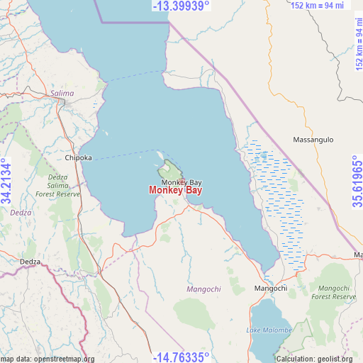
Monkey Bay GPS coordinates[2]
14° 4' 56.604" South, 34° 54' 59.472" East
| Map corner | latitude | longitude |
|---|---|---|
| Upper-left | -13.39939°, | 34.2134° |
| Center: | -14.08239°, | 34.91652° |
| Lower-right: | -14.76335°, | 35.61965° |
| Map W x H: | 151.7×151.7 km | = 94.3×94.3mi |
| max Lat: | -9.70237° ⇑48.6% North |
| Monkey Bay: | -14.08239° |
| min Lat: | ⇓51.4% South -16.91995° |
| min Long | Monkey Bay | max Long |
| 32.88019° | 34.91652° | 35.65067° |
| W 62.9%⇐ | ⇒37.1% E |
Elevation
Elevation of Monkey Bay is 484 m = 1588 ft, and this is 384.7 m = 1262 ft below average elevation for this country.
| Max E: |
1608 m = 5276 ft | 91.4% |
| Avg. | 868.7 m = 2850 ft | |
| Monkey Bay | 484 m = 1588 ft | |
Min E: |
55 m = 180 ft | 8.6% |
See also: Malawi elevation on elevation.city.
Geographical zone
Monkey Bay is located in South Torrid zone (between Equator and Tropic of Capricorn). Distance of this Southern Tropic circle is 1040.1 km =646.3 mi to South.| Distance of | km | miles | from Monkey Bay |
|---|---|---|---|
| Equator | 1565.8 | 972.9 | to North |
| Tropic Capricorn | 1040.1 | 646.3 | to South |
| Antarctic Circle | 5835.4 | 3625.9 | to South |
| South Pole | 8441.2 | 5245.1 | to South |


Nearby cities:
15 places around Monkey Bay: (largest is in red/bold)
• Balaka
99.8 km =62 mi,  177°
177°
• Chipoka
44.4 km =27.6 mi,  282°
282°
• Dedza
70.9 km =44.1 mi,  242°
242°
• Dowa
115.9 km =72 mi,  294°
294°
• Lilongwe
122.5 km =76.1 mi, 276°
• Liwonde
114.4 km =71.1 mi,  163°
163°
• Machinga
127.6 km =79.3 mi, 161°
• Mangochi
57.8 km =35.9 mi,  139°
139°
• Mponela
141 km =87.6 mi,  295°
295°
• Neno
149 km =92.6 mi,  190°
190°
• Nkhotakota
144.9 km =90 mi,  332°
332°
• Ntcheu
87.4 km =54.3 mi,  200°
200°
• Ntchisi
124.5 km =77.4 mi, 299°
• Salima
59.7 km =37.1 mi, 304°
• Zomba
151.3 km =94 mi, 163°
Sources, notices
• [Note1] Compared only with cities in Malawi existing in our database
• [Src1] Map data: © OpenStreetMap contributors (CC-BY-SA)
• [Src2] Other city data from geonames.org with taken over terms of usage.
• [Src3] Geographical zone / Annual Mean Temperature by Robert A. Rohde @ Wikipedia
