Birnin Gaouré geodata
Birnin Gaouré (Dosso) is a seat of a second-order administrative division; located in Niger in Africa/Niamey (GMT+1) time zone. In our database, there are 38 cities with bigger population. Compared to other cities in Niger, 93% of cities are located further ↑North; 83.7% of cities are located further →East and 93% of cities have higher elevation than Birnin Gaouré. Note1


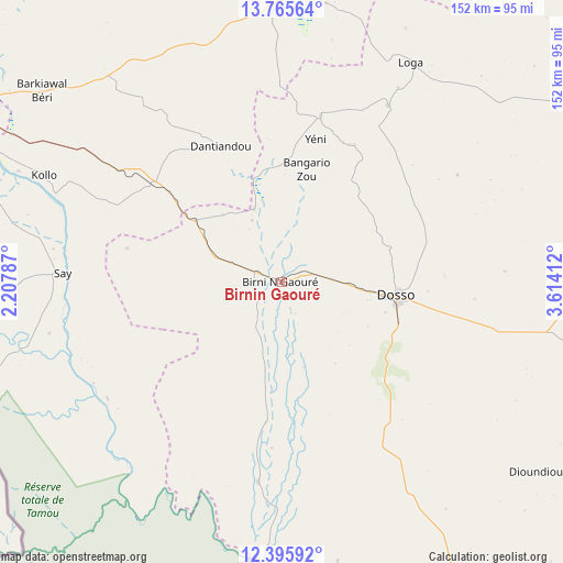
Birnin Gaouré GPS coordinates[2]
13° 4' 54.228" North, 2° 54' 39.564" East
| Map corner | latitude | longitude |
|---|---|---|
| Upper-left | 13.76564°, | 2.20787° |
| Center: | 13.08173°, | 2.91099° |
| Lower-right: | 12.39592°, | 3.61412° |
| Map W x H: | 152.3×152.3 km | = 94.6×94.6mi |
| max Lat: | 18.73694° ⇑93% North |
| Birnin Gaouré: | 13.08173° |
| min Lat: | ⇓7% South 11.88435° |
| min Long | Birnin Gaouré | max Long |
| 0.75306° | 2.91099° | 13.10921° |
| W 16.3%⇐ | ⇒83.7% E |
Elevation
Elevation of Birnin Gaouré is 193 m = 633 ft, and this is 149.8 m = 491 ft below average elevation for this country.
| Max E: |
525 m = 1722 ft | 93% |
| Avg. | 342.8 m = 1125 ft | |
| Birnin Gaouré | 193 m = 633 ft | |
Min E: |
177 m = 581 ft | 7% |
See also: Niger elevation on elevation.city.
Geographical zone
Birnin Gaouré is located in North Torrid zone (between Equator and Tropic of Cancer). Distance of this Northern Tropic circle is 1151.4 km =715.4 mi to North.| Distance of | km | miles | from Birnin Gaouré |
|---|---|---|---|
| North Pole | 8552.5 | 5314.3 | to North |
| Arctic Circle | 5946.6 | 3695 | to North |
| Tropic Cancer | 1151.4 | 715.4 | to North |
| Equator | 1454.6 | 903.8 | to South |


Nearby cities:
15 places around Birnin Gaouré: (largest is in red/bold)
• Ayorou
282.7 km =175.7 mi,  310°
310°
• Birni N Konni
265.2 km =164.8 mi,  72°
72°
• Dogondoutchi
135.7 km =84.3 mi,  62°
62°
• Dosso
30.8 km =19.1 mi,  96°
96°
• Filingué
147.9 km =91.9 mi,  17°
17°
• Gaya
145.4 km =90.3 mi,  156°
156°
• Illéla
294.9 km =183.2 mi, 58°
• Kollo
66.7 km =41.4 mi,  291°
291°
• Loga
68.8 km =42.8 mi,  30°
30°
• Niamey
99.1 km =61.6 mi,  298°
298°
• Ouallam
163.7 km =101.7 mi,  327°
327°
• Say
58.7 km =36.5 mi,  272°
272°
• Tahoua
324.2 km =201.4 mi,  51°
51°
• Tillabéri
201.1 km =125 mi, 308°
• Téra
255 km =158.4 mi, 293°
Sources, notices
• [Note1] Compared only with cities in Niger existing in our database
• [Src1] Map data: © OpenStreetMap contributors (CC-BY-SA)
• [Src2] Other city data from geonames.org with taken over terms of usage.
• [Src3] Geographical zone / Annual Mean Temperature by Robert A. Rohde @ Wikipedia
