Say geodata
Say (Tillabéri) is a seat of a second-order administrative division; located in Niger in Africa/Niamey (GMT+1) time zone. With population of 10,387 people, there are 30 cities with bigger population in this country. Compared to other cities in Niger, 90.7% of cities are located further ↑North; 86% of cities are located further →East and 97.7% of cities have higher elevation than Say. Note1


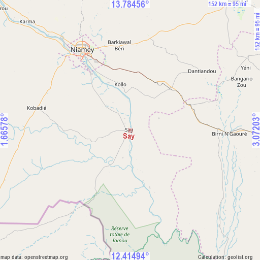
Say GPS coordinates[2]
13° 6' 2.52" North, 2° 22' 8.04" East
| Map corner | latitude | longitude |
|---|---|---|
| Upper-left | 13.78456°, | 1.66578° |
| Center: | 13.1007°, | 2.3689° |
| Lower-right: | 12.41494°, | 3.07203° |
| Map W x H: | 152.3×152.3 km | = 94.6×94.6mi |
| max Lat: | 18.73694° ⇑90.7% North |
| Say: | 13.1007° |
| min Lat: | ⇓9.3% South 11.88435° |
| min Long | Say | max Long |
| 0.75306° | 2.3689° | 13.10921° |
| W 14%⇐ | ⇒86% E |
Elevation
Elevation of Say is 181 m = 594 ft, and this is 161.8 m = 531 ft below average elevation for this country.
| Max E: |
525 m = 1722 ft | 97.7% |
| Avg. | 342.8 m = 1125 ft | |
| Say | 181 m = 594 ft | |
Min E: |
177 m = 581 ft | 2.3% |
See also: Niger elevation on elevation.city.
Geographical zone
Say is located in North Torrid zone (between Equator and Tropic of Cancer). Distance of this Northern Tropic circle is 1149.3 km =714.1 mi to North.| Distance of | km | miles | from Say |
|---|---|---|---|
| North Pole | 8550.4 | 5313 | to North |
| Arctic Circle | 5944.5 | 3693.7 | to North |
| Tropic Cancer | 1149.3 | 714.1 | to North |
| Equator | 1456.7 | 905.2 | to South |


Nearby cities:
15 places around Say: (largest is in red/bold)
• Ayorou
239.6 km =148.9 mi,  319°
319°
• Birni N Konni
321 km =199.5 mi,  76°
76°
• Birnin Gaouré
58.7 km =36.5 mi,  92°
92°
• Dogondoutchi
189.1 km =117.5 mi,  71°
71°
• Dosso
89.5 km =55.6 mi, 93°
• Filingué
172.8 km =107.4 mi,  36°
36°
• Gaya
179 km =111.2 mi,  139°
139°
• Illéla
345.3 km =214.6 mi,  64°
64°
• Kollo
22.9 km =14.2 mi,  351°
351°
• Loga
109.7 km =68.2 mi, 58°
• Niamey
53.8 km =33.4 mi,  328°
328°
• Ouallam
138.6 km =86.1 mi, 347°
• Tahoua
370.7 km =230.3 mi, 57°
• Tillabéri
157.8 km =98.1 mi, 321°
• Téra
201.7 km =125.3 mi,  300°
300°
Sources, notices
• [Note1] Compared only with cities in Niger existing in our database
• [Src1] Map data: © OpenStreetMap contributors (CC-BY-SA)
• [Src2] Other city data from geonames.org with taken over terms of usage.
• [Src3] Geographical zone / Annual Mean Temperature by Robert A. Rohde @ Wikipedia
