Dosso geodata
Dosso is a seat of a first-order administrative division; located in Niger in Africa/Niamey (GMT+1) time zone. With population of 49,750 people, there are 6 cities with bigger population in this country. Compared to other cities in Niger, 95.3% of cities are located further ↑North; 81.4% of cities are located further →East and 86% of cities have higher elevation than Dosso. Note1


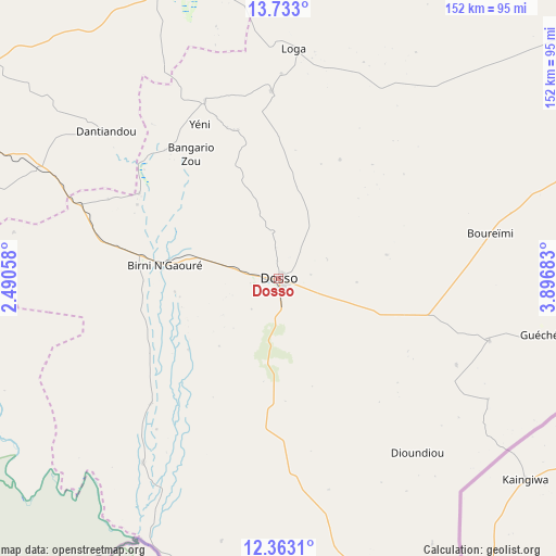
Dosso GPS coordinates[2]
13° 2' 56.4" North, 3° 11' 37.32" East
| Map corner | latitude | longitude |
|---|---|---|
| Upper-left | 13.733°, | 2.49058° |
| Center: | 13.049°, | 3.1937° |
| Lower-right: | 12.3631°, | 3.89683° |
| Map W x H: | 152.3×152.3 km | = 94.6×94.6mi |
| max Lat: | 18.73694° ⇑95.3% North |
| Dosso: | 13.049° |
| min Lat: | ⇓4.7% South 11.88435° |
| min Long | Dosso | max Long |
| 0.75306° | 3.1937° | 13.10921° |
| W 18.6%⇐ | ⇒81.4% E |
Elevation
Elevation of Dosso is 218 m = 715 ft, and this is 124.8 m = 409 ft below average elevation for this country.
| Max E: |
525 m = 1722 ft | 86% |
| Avg. | 342.8 m = 1125 ft | |
| Dosso | 218 m = 715 ft | |
Min E: |
177 m = 581 ft | 14% |
See also: Dosso elevation on elevation.city.
Geographical zone
Dosso is located in North Torrid zone (between Equator and Tropic of Cancer). Distance of this Northern Tropic circle is 1155 km =717.7 mi to North.| Distance of | km | miles | from Dosso |
|---|---|---|---|
| North Pole | 8556.1 | 5316.5 | to North |
| Arctic Circle | 5950.3 | 3697.3 | to North |
| Tropic Cancer | 1155 | 717.7 | to North |
| Equator | 1450.9 | 901.5 | to South |


Nearby cities:
15 places around Dosso: (largest is in red/bold)
• Ayorou
308.8 km =191.9 mi,  307°
307°
• Birni N Konni
237.4 km =147.5 mi,  69°
69°
• Birnin Gaouré
30.8 km =19.1 mi,  276°
276°
• Dogondoutchi
111.5 km =69.3 mi,  53°
53°
• Filingué
145.5 km =90.4 mi,  5°
5°
• Gaya
132.4 km =82.3 mi,  167°
167°
• Illéla
271.4 km =168.6 mi, 54°
• Kollo
96.8 km =60.1 mi,  287°
287°
• Loga
62.9 km =39.1 mi,  4°
4°
• Niamey
128.2 km =79.7 mi, 293°
• Ouallam
184.9 km =114.9 mi,  319°
319°
• Say
89.5 km =55.6 mi,  273°
273°
• Tahoua
303.3 km =188.5 mi, 47°
• Tillabéri
227.8 km =141.5 mi,  304°
304°
• Téra
284.6 km =176.8 mi, 292°
Sources, notices
• [Note1] Compared only with cities in Niger existing in our database
• [Src1] Map data: © OpenStreetMap contributors (CC-BY-SA)
• [Src2] Other city data from geonames.org with taken over terms of usage.
• [Src3] Geographical zone / Annual Mean Temperature by Robert A. Rohde @ Wikipedia
