Gaya geodata
Gaya (Dosso) is a seat of a second-order administrative division; located in Niger in Africa/Niamey (GMT+1) time zone. With population of 33,051 people, there are 9 cities with bigger population in this country. Compared to other cities in Niger, 100% of cities are located further ↑North; 74.4% of cities are located further →East and 100% of cities have higher elevation than Gaya. Note1


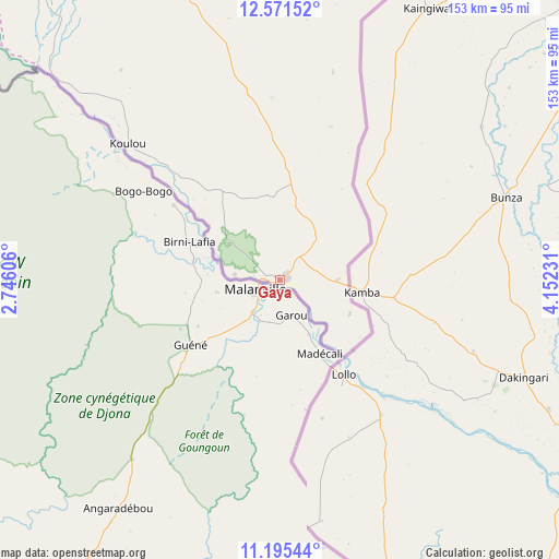
Gaya GPS coordinates[2]
11° 53' 3.66" North, 3° 26' 57.084" East
| Map corner | latitude | longitude |
|---|---|---|
| Upper-left | 12.57152°, | 2.74606° |
| Center: | 11.88435°, | 3.44919° |
| Lower-right: | 11.19544°, | 4.15231° |
| Map W x H: | 153×153 km | = 95.1×95.1mi |
| max Lat: | 18.73694° ⇑100% North |
| Gaya: | 11.88435° |
| min Lat: | ⇓0% South 11.88435° |
| min Long | Gaya | max Long |
| 0.75306° | 3.44919° | 13.10921° |
| W 25.6%⇐ | ⇒74.4% E |
Elevation
Elevation of Gaya is 177 m = 581 ft, and this is 165.8 m = 544 ft below average elevation for this country.
| Max E: |
525 m = 1722 ft | 100% |
| Avg. | 342.8 m = 1125 ft | |
| Gaya | 177 m = 581 ft | |
Min E: |
177 m = 581 ft | 0% |
See also: Niger elevation on elevation.city.
Geographical zone
Gaya is located in North Torrid zone (between Equator and Tropic of Cancer). Distance of this Northern Tropic circle is 1284.5 km =798.2 mi to North.| Distance of | km | miles | from Gaya |
|---|---|---|---|
| North Pole | 8685.6 | 5397 | to North |
| Arctic Circle | 6079.8 | 3777.8 | to North |
| Tropic Cancer | 1284.5 | 798.2 | to North |
| Equator | 1321.4 | 821.1 | to South |


Nearby cities:
15 places around Gaya: (largest is in red/bold)
• Birni N Konni
288.6 km =179.3 mi,  42°
42°
• Birnin Gaouré
145.4 km =90.3 mi,  336°
336°
• Dogondoutchi
205 km =127.4 mi,  17°
17°
• Dosso
132.4 km =82.3 mi,  347°
347°
• Filingué
274.8 km =170.8 mi,  357°
357°
• Illéla
346.1 km =215.1 mi,  34°
34°
• Kollo
198.6 km =123.4 mi,  322°
322°
• Loga
193.6 km =120.3 mi, 353°
• Madaoua
365 km =226.8 mi,  48°
48°
• Niamey
232.2 km =144.3 mi, 321°
• Ouallam
308.1 km =191.4 mi,  331°
331°
• Say
179 km =111.2 mi, 319°
• Tahoua
387.7 km =240.9 mi, 30°
• Tillabéri
336.7 km =209.2 mi, 320°
• Téra
375.6 km =233.4 mi,  308°
308°
Sources, notices
• [Note1] Compared only with cities in Niger existing in our database
• [Src1] Map data: © OpenStreetMap contributors (CC-BY-SA)
• [Src2] Other city data from geonames.org with taken over terms of usage.
• [Src3] Geographical zone / Annual Mean Temperature by Robert A. Rohde @ Wikipedia
