Niamey geodata
Niamey is a capital of a political entity; located in Niger in Africa/Niamey (GMT+1) time zone. With population of 774,235 people, there are 0 cities with bigger population in this country. Compared to other cities in Niger, 72.1% of cities are located further ↑North; 90.7% of cities are located further →East and 90.7% of cities have higher elevation than Niamey. Note1


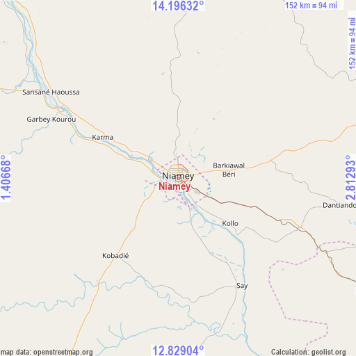
Niamey GPS coordinates[2]
13° 30' 49.176" North, 2° 6' 35.28" East
| Map corner | latitude | longitude |
|---|---|---|
| Upper-left | 14.19632°, | 1.40668° |
| Center: | 13.51366°, | 2.1098° |
| Lower-right: | 12.82904°, | 2.81293° |
| Map W x H: | 152×152 km | = 94.4×94.4mi |
| max Lat: | 18.73694° ⇑72.1% North |
| Niamey: | 13.51366° |
| min Lat: | ⇓27.9% South 11.88435° |
| min Long | Niamey | max Long |
| 0.75306° | 2.1098° | 13.10921° |
| W 9.3%⇐ | ⇒90.7% E |
Elevation
Elevation of Niamey is 206 m = 676 ft, and this is 136.8 m = 449 ft below average elevation for this country.
| Max E: |
525 m = 1722 ft | 90.7% |
| Avg. | 342.8 m = 1125 ft | |
| Niamey | 206 m = 676 ft | |
Min E: |
177 m = 581 ft | 9.3% |
See also: Niamey elevation on elevation.city.
Geographical zone
Niamey is located in North Torrid zone (between Equator and Tropic of Cancer). Distance of this Northern Tropic circle is 1103.3 km =685.6 mi to North.| Distance of | km | miles | from Niamey |
|---|---|---|---|
| North Pole | 8504.5 | 5284.4 | to North |
| Arctic Circle | 5898.6 | 3665.2 | to North |
| Tropic Cancer | 1103.3 | 685.6 | to North |
| Equator | 1502.6 | 933.7 | to South |


Nearby cities:
15 places around Niamey: (largest is in red/bold)
• Ayorou
186.7 km =116 mi,  316°
316°
• Birni N Konni
340.8 km =211.8 mi,  84°
84°
• Birnin Gaouré
99.1 km =61.6 mi,  118°
118°
• Dogondoutchi
207.6 km =129 mi,  86°
86°
• Dosso
128.2 km =79.7 mi,  113°
113°
• Filingué
160.2 km =99.5 mi,  54°
54°
• Gaya
232.2 km =144.3 mi,  141°
141°
• Illéla
354.1 km =220 mi,  72°
72°
• Kollo
34 km =21.1 mi,  133°
133°
• Loga
122.2 km =75.9 mi, 84°
• Ouallam
89.3 km =55.5 mi,  358°
358°
• Say
53.8 km =33.4 mi,  148°
148°
• Tahoua
373.3 km =232 mi, 65°
• Tillabéri
104.7 km =65.1 mi, 317°
• Téra
156.5 km =97.2 mi,  290°
290°
Sources, notices
• [Note1] Compared only with cities in Niger existing in our database
• [Src1] Map data: © OpenStreetMap contributors (CC-BY-SA)
• [Src2] Other city data from geonames.org with taken over terms of usage.
• [Src3] Geographical zone / Annual Mean Temperature by Robert A. Rohde @ Wikipedia
