Kollo geodata
Kollo (Tillabéri) is a seat of a second-order administrative division; located in Niger in Africa/Niamey (GMT+1) time zone. With population of 10,376 people, there are 31 cities with bigger population in this country. Compared to other cities in Niger, 86% of cities are located further ↑North; 88.4% of cities are located further →East and 95.3% of cities have higher elevation than Kollo. Note1


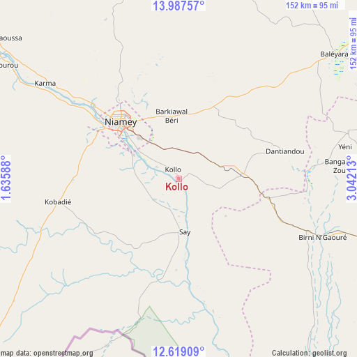
Kollo GPS coordinates[2]
13° 18' 15.48" North, 2° 20' 20.4" East
| Map corner | latitude | longitude |
|---|---|---|
| Upper-left | 13.98757°, | 1.63588° |
| Center: | 13.3043°, | 2.339° |
| Lower-right: | 12.61909°, | 3.04213° |
| Map W x H: | 152.2×152.2 km | = 94.6×94.6mi |
| max Lat: | 18.73694° ⇑86% North |
| Kollo: | 13.3043° |
| min Lat: | ⇓14% South 11.88435° |
| min Long | Kollo | max Long |
| 0.75306° | 2.339° | 13.10921° |
| W 11.6%⇐ | ⇒88.4% E |
Elevation
Elevation of Kollo is 189 m = 620 ft, and this is 153.8 m = 505 ft below average elevation for this country.
| Max E: |
525 m = 1722 ft | 95.3% |
| Avg. | 342.8 m = 1125 ft | |
| Kollo | 189 m = 620 ft | |
Min E: |
177 m = 581 ft | 4.7% |
See also: Niger elevation on elevation.city.
Geographical zone
Kollo is located in North Torrid zone (between Equator and Tropic of Cancer). Distance of this Northern Tropic circle is 1126.6 km =700 mi to North.| Distance of | km | miles | from Kollo |
|---|---|---|---|
| North Pole | 8527.8 | 5298.9 | to North |
| Arctic Circle | 5921.9 | 3679.7 | to North |
| Tropic Cancer | 1126.6 | 700 | to North |
| Equator | 1479.3 | 919.2 | to South |


Nearby cities:
15 places around Kollo: (largest is in red/bold)
• Ayorou
220.6 km =137.1 mi,  315°
315°
• Birni N Konni
319.4 km =198.5 mi,  80°
80°
• Birnin Gaouré
66.7 km =41.4 mi,  111°
111°
• Dogondoutchi
186.3 km =115.8 mi, 78°
• Dosso
96.8 km =60.1 mi, 107°
• Filingué
157.2 km =97.7 mi,  42°
42°
• Gaya
198.6 km =123.4 mi,  142°
142°
• Illéla
338.9 km =210.6 mi,  67°
67°
• Loga
102.9 km =63.9 mi, 70°
• Niamey
34 km =21.1 mi,  313°
313°
• Ouallam
115.8 km =72 mi,  346°
346°
• Say
22.9 km =14.2 mi,  171°
171°
• Tahoua
361.8 km =224.8 mi,  60°
60°
• Tillabéri
138.6 km =86.1 mi, 316°
• Téra
188.4 km =117.1 mi,  294°
294°
Sources, notices
• [Note1] Compared only with cities in Niger existing in our database
• [Src1] Map data: © OpenStreetMap contributors (CC-BY-SA)
• [Src2] Other city data from geonames.org with taken over terms of usage.
• [Src3] Geographical zone / Annual Mean Temperature by Robert A. Rohde @ Wikipedia
