Ringebu geodata
Ringebu (Oppland) is a seat of a second-order administrative division; located in Norway in Europe/Oslo (GMT+2) time zone. In our database, there are 488 cities with bigger population. Compared to other cities in Norway, 60.4% of cities are located further ↓South; 50% of cities are located further ←West and 83.5% of cities have lower elevation than Ringebu. Note1


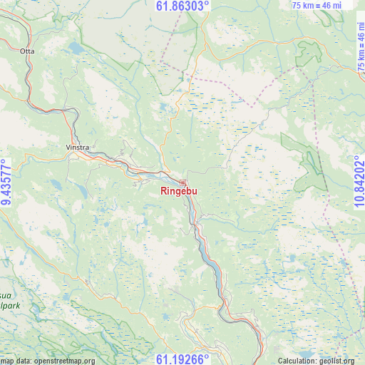
Ringebu GPS coordinates[2]
61° 31' 46.74" North, 10° 8' 20.004" East
| Map corner | latitude | longitude |
|---|---|---|
| Upper-left | 61.86303°, | 9.43577° |
| Center: | 61.52965°, | 10.13889° |
| Lower-right: | 61.19266°, | 10.84202° |
| Map W x H: | 74.5×74.5 km | = 46.3×46.3mi |
| max Lat: | 71.04137° ⇑39.6% North |
| Ringebu: | 61.52965° |
| min Lat: | ⇓60.4% South 58.0274° |
| min Long | Ringebu | max Long |
| 4.71485° | 10.13889° | 31.11066° |
| W 50%⇐ | ⇒50% E |
Elevation
Elevation of Ringebu is 200 m = 656 ft, and this is 95.8 m = 314 ft above average elevation for this country.
| Max E: |
897 m = 2943 ft | 16.5% |
| Ringebu | 200 m 656 ft | |
| Avg. | 104.2 m = 342 ft | |
Min E: |
1 m = 3 ft | 83.5% |
See also: Norway elevation on elevation.city.
Geographical zone
Ringebu is located in North temperate zone (between Tropic of Cancer and the Arctic Circle). Distance of this North polar circle is 559.7 km =347.8 mi to North.| Distance of | km | miles | from Ringebu |
|---|---|---|---|
| North Pole | 3165.6 | 1967 | to North |
| Arctic Circle | 559.7 | 347.8 | to North |
| Tropic Cancer | 4235.5 | 2631.8 | to South |
| Equator | 6841.5 | 4251.1 | to South |


Nearby cities:
15 places around Ringebu: (largest is in red/bold)
• Bergset
63.7 km =39.6 mi,  50°
50°
• Dale
43.6 km =27.1 mi,  308°
308°
• Follebu
35.8 km =22.2 mi,  167°
167°
• Forset
36.4 km =22.6 mi,  179°
179°
• Hundorp
10.9 km =6.8 mi,  285°
285°
• Koppang
48.3 km =30 mi,  84°
84°
• Kvam
28.2 km =17.5 mi,  302°
302°
• Lillehammer
49.3 km =30.6 mi,  159°
159°
• Otta
41.7 km =25.9 mi, 310°
• Segalstad
33.3 km =20.7 mi, 171°
• Segalstad bru
33.8 km =21 mi, 172°
• Svarstad
60 km =37.3 mi,  71°
71°
• Tretten
25.5 km =15.8 mi, 160°
• Vinstra
21.8 km =13.5 mi, 289°
• Vågåmo
67 km =41.6 mi, 304°
Sources, notices
• [Note1] Compared only with cities in Norway existing in our database
• [Src1] Map data: © OpenStreetMap contributors (CC-BY-SA)
• [Src2] Other city data from geonames.org with taken over terms of usage.
• [Src3] Geographical zone / Annual Mean Temperature by Robert A. Rohde @ Wikipedia
