Ṭikāpur geodata
Ṭikāpur (Far Western) is a populated place; located in Nepal in Asia/Kathmandu (GMT+5.75) time zone. With population of 44,758 people, there are 20 cities with bigger population in this country. Compared to other cities in Nepal, 78.4% of cities are located further ↓South; 93.2% of cities are located further →East and 75.7% of cities have higher elevation than Ṭikāpur. Note1


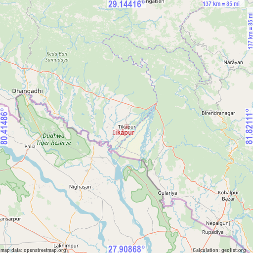
Ṭikāpur GPS coordinates[2]
28° 31' 41.628" North, 81° 7' 4.728" East
| Map corner | latitude | longitude |
|---|---|---|
| Upper-left | 29.14416°, | 80.41486° |
| Center: | 28.52823°, | 81.11798° |
| Lower-right: | 27.90868°, | 81.82111° |
| Map W x H: | 137.4×137.4 km | = 85.4×85.4mi |
| max Lat: | 30.04651° ⇑21.6% North |
| Ṭikāpur: | 28.52823° |
| min Lat: | ⇓78.4% South 26.45505° |
| min Long | Ṭikāpur | max Long |
| 80.17715° | 81.11798° | 88.09436° |
| W 6.8%⇐ | ⇒93.2% E |
Elevation
Elevation of Ṭikāpur is 168 m = 551 ft, and this is 1007.2 m = 3304 ft below average elevation for this country.
| Max E: |
5251 m = 17228 ft | 75.7% |
| Avg. | 1175.2 m = 3856 ft | |
| Ṭikāpur | 168 m = 551 ft | |
Min E: |
72 m = 236 ft | 24.3% |
See also: Ṭikāpur elevation on elevation.city.
Geographical zone
Ṭikāpur is located in North temperate zone (between Tropic of Cancer and the Arctic Circle). Distance of this Northern Tropic circle is 566.1 km =351.8 mi to South.| Distance of | km | miles | from Ṭikāpur |
|---|---|---|---|
| North Pole | 6835 | 4247.1 | to North |
| Arctic Circle | 4229.1 | 2627.8 | to North |
| Tropic Cancer | 566.1 | 351.8 | to South |
| Equator | 3172 | 1971 | to South |


Nearby cities:
15 places around Ṭikāpur: (largest is in red/bold)
• Achhām
60.7 km =37.7 mi,  17°
17°
• Bardiyā
34.2 km =21.3 mi,  137°
137°
• Besisahar
130.8 km =81.3 mi,  104°
104°
• Bhojpur
92.1 km =57.2 mi, 135°
• Birendranagar
51 km =31.7 mi,  80°
80°
• Dadeldhurā
100.3 km =62.3 mi,  328°
328°
• Dailekh
67.6 km =42 mi,  58°
58°
• Dhangaḍhi̇̄
55 km =34.2 mi,  290°
290°
• Dipayal
83.3 km =51.8 mi,  347°
347°
• Gulariyā
42.2 km =26.2 mi,  148°
148°
• Mahendranagar
103.7 km =64.4 mi,  297°
297°
• Nepalgunj
72.2 km =44.9 mi, 137°
• Salyān
104.2 km =64.7 mi, 99°
• Surkhet
64.6 km =40.1 mi,  91°
91°
• Tulsīpur
123.6 km =76.8 mi,  110°
110°
Sources, notices
• [Note1] Compared only with cities in Nepal existing in our database
• [Src1] Map data: © OpenStreetMap contributors (CC-BY-SA)
• [Src2] Other city data from geonames.org with taken over terms of usage.
• [Src3] Geographical zone / Annual Mean Temperature by Robert A. Rohde @ Wikipedia
