Bardiyā geodata
Bardiyā (Mid Western) is a seat of a third-order administrative division; located in Nepal in Asia/Kathmandu (GMT+5.75) time zone. In our database, there are 62 cities with bigger population. Compared to other cities in Nepal, 73% of cities are located further ↓South; 89.2% of cities are located further →East and 78.4% of cities have higher elevation than Bardiyā. Note1


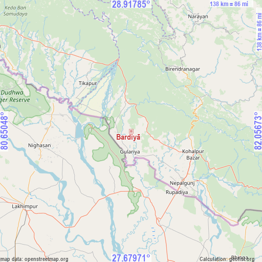
Bardiyā GPS coordinates[2]
28° 18' 2.088" North, 81° 21' 12.96" East
| Map corner | latitude | longitude |
|---|---|---|
| Upper-left | 28.91785°, | 80.65048° |
| Center: | 28.30058°, | 81.3536° |
| Lower-right: | 27.67971°, | 82.05673° |
| Map W x H: | 137.7×137.7 km | = 85.6×85.6mi |
| max Lat: | 30.04651° ⇑27% North |
| Bardiyā: | 28.30058° |
| min Lat: | ⇓73% South 26.45505° |
| min Long | Bardiyā | max Long |
| 80.17715° | 81.3536° | 88.09436° |
| W 10.8%⇐ | ⇒89.2% E |
Elevation
Elevation of Bardiyā is 151 m = 495 ft, and this is 1024.2 m = 3360 ft below average elevation for this country.
| Max E: |
5251 m = 17228 ft | 78.4% |
| Avg. | 1175.2 m = 3856 ft | |
| Bardiyā | 151 m = 495 ft | |
Min E: |
72 m = 236 ft | 21.6% |
See also: Nepal elevation on elevation.city.
Geographical zone
Bardiyā is located in North temperate zone (between Tropic of Cancer and the Arctic Circle). Distance of this Northern Tropic circle is 540.8 km =336 mi to South.| Distance of | km | miles | from Bardiyā |
|---|---|---|---|
| North Pole | 6860.3 | 4262.8 | to North |
| Arctic Circle | 4254.4 | 2643.6 | to North |
| Tropic Cancer | 540.8 | 336 | to South |
| Equator | 3146.7 | 1955.3 | to South |


Nearby cities:
15 places around Bardiyā: (largest is in red/bold)
• Achhām
83.5 km =51.9 mi,  356°
356°
• Besisahar
104 km =64.6 mi,  94°
94°
• Bhojpur
58 km =36 mi,  134°
134°
• Birendranagar
43.3 km =26.9 mi,  39°
39°
• Dadeldhurā
134.1 km =83.3 mi,  325°
325°
• Dailekh
69.8 km =43.4 mi,  29°
29°
• Dhangaḍhi̇̄
86.9 km =54 mi,  300°
300°
• Dipayal
114.1 km =70.9 mi,  339°
339°
• Gulariyā
10.6 km =6.6 mi,  184°
184°
• Jumla
135.2 km =84 mi, 36°
• Nepalgunj
38 km =23.6 mi,  137°
137°
• Salyān
80.4 km =50 mi,  83°
83°
• Surkhet
48.1 km =29.9 mi,  59°
59°
• Tulsīpur
94.4 km =58.7 mi,  101°
101°
• Ṭikāpur
34.2 km =21.3 mi,  317°
317°
Sources, notices
• [Note1] Compared only with cities in Nepal existing in our database
• [Src1] Map data: © OpenStreetMap contributors (CC-BY-SA)
• [Src2] Other city data from geonames.org with taken over terms of usage.
• [Src3] Geographical zone / Annual Mean Temperature by Robert A. Rohde @ Wikipedia
