Jumla geodata
Jumla (Mid Western) is a populated place; located in Nepal in Asia/Kathmandu (GMT+5.75) time zone. With population of 9,073 people, there are 46 cities with bigger population in this country. Compared to other cities in Nepal, 93.2% of cities are located further ↓South; 75.7% of cities are located further →East and 87.8% of cities have lower elevation than Jumla. Note1


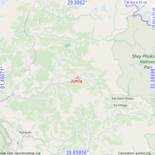
Jumla GPS coordinates[2]
29° 16' 28.992" North, 82° 11' 1.788" East
| Map corner | latitude | longitude |
|---|---|---|
| Upper-left | 29.8862°, | 81.48071° |
| Center: | 29.27472°, | 82.18383° |
| Lower-right: | 28.65956°, | 82.88696° |
| Map W x H: | 136.4×136.4 km | = 84.8×84.8mi |
| max Lat: | 30.04651° ⇑6.8% North |
| Jumla: | 29.27472° |
| min Lat: | ⇓93.2% South 26.45505° |
| min Long | Jumla | max Long |
| 80.17715° | 82.18383° | 88.09436° |
| W 24.3%⇐ | ⇒75.7% E |
Elevation
Elevation of Jumla is 2354 m = 7723 ft, and this is 1178.8 m = 3867 ft above average elevation for this country.
| Max E: |
5251 m = 17228 ft | 12.2% |
| Jumla | 2354 m 7723 ft | |
| Avg. | 1175.2 m = 3856 ft | |
Min E: |
72 m = 236 ft | 87.8% |
See also: Nepal elevation on elevation.city.
Geographical zone
Jumla is located in North temperate zone (between Tropic of Cancer and the Arctic Circle). Distance of this Northern Tropic circle is 649.1 km =403.3 mi to South.| Distance of | km | miles | from Jumla |
|---|---|---|---|
| North Pole | 6752 | 4195.5 | to North |
| Arctic Circle | 4146.1 | 2576.3 | to North |
| Tropic Cancer | 649.1 | 403.3 | to South |
| Equator | 3255 | 2022.6 | to South |


Nearby cities:
15 places around Jumla: (largest is in red/bold)
• Achhām
89.4 km =55.6 mi,  253°
253°
• Bardiyā
135.2 km =84 mi,  216°
216°
• Besisahar
117.8 km =73.2 mi,  169°
169°
• Birendranagar
92 km =57.2 mi, 215°
• Chhibro
79.9 km =49.6 mi,  335°
335°
• Dailekh
66.4 km =41.3 mi, 223°
• Dipayal
120.7 km =75 mi,  269°
269°
• Gulariyā
144.3 km =89.7 mi,  214°
214°
• Khārpū
85.9 km =53.4 mi,  358°
358°
• Nepalgunj
147 km =91.3 mi,  202°
202°
• Salyān
99.7 km =62 mi,  180°
180°
• Simikot
84.2 km =52.3 mi, 335°
• Surkhet
93 km =57.8 mi, 205°
• Tulsīpur
127.7 km =79.3 mi, 175°
• Ṭikāpur
132.9 km =82.6 mi,  231°
231°
Sources, notices
• [Note1] Compared only with cities in Nepal existing in our database
• [Src1] Map data: © OpenStreetMap contributors (CC-BY-SA)
• [Src2] Other city data from geonames.org with taken over terms of usage.
• [Src3] Geographical zone / Annual Mean Temperature by Robert A. Rohde @ Wikipedia
