Achhām geodata
Achhām (Far Western) is a seat of a third-order administrative division; located in Nepal in Asia/Kathmandu (GMT+5.75) time zone. In our database, there are 62 cities with bigger population. Compared to other cities in Nepal, 90.5% of cities are located further ↓South; 91.9% of cities are located further →East and 55.4% of cities have lower elevation than Achhām. Note1


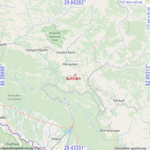
Achhām GPS coordinates[2]
29° 3' 0" North, 81° 18' 0" East
| Map corner | latitude | longitude |
|---|---|---|
| Upper-left | 29.66283°, | 80.59688° |
| Center: | 29.05°, | 81.3° |
| Lower-right: | 28.43351°, | 82.00313° |
| Map W x H: | 136.7×136.7 km | = 84.9×84.9mi |
| max Lat: | 30.04651° ⇑9.5% North |
| Achhām: | 29.05° |
| min Lat: | ⇓90.5% South 26.45505° |
| min Long | Achhām | max Long |
| 80.17715° | 81.3° | 88.09436° |
| W 8.1%⇐ | ⇒91.9% E |
Elevation
Elevation of Achhām is 1284 m = 4213 ft, and this is 108.8 m = 357 ft above average elevation for this country.
| Max E: |
5251 m = 17228 ft | 44.6% |
| Achhām | 1284 m 4213 ft | |
| Avg. | 1175.2 m = 3856 ft | |
Min E: |
72 m = 236 ft | 55.4% |
See also: Nepal elevation on elevation.city.
Geographical zone
Achhām is located in North temperate zone (between Tropic of Cancer and the Arctic Circle). Distance of this Northern Tropic circle is 624.1 km =387.8 mi to South.| Distance of | km | miles | from Achhām |
|---|---|---|---|
| North Pole | 6777 | 4211 | to North |
| Arctic Circle | 4171.1 | 2591.8 | to North |
| Tropic Cancer | 624.1 | 387.8 | to South |
| Equator | 3230.1 | 2007.1 | to South |


Nearby cities:
15 places around Achhām: (largest is in red/bold)
• Bardiyā
83.5 km =51.9 mi,  176°
176°
• Birendranagar
59.5 km =37 mi,  146°
146°
• Chhibro
110.7 km =68.8 mi,  28°
28°
• Dadeldhurā
75.1 km =46.7 mi,  291°
291°
• Dailekh
46 km =28.6 mi,  119°
119°
• Dhangaḍhi̇̄
79.3 km =49.3 mi,  240°
240°
• Dipayal
42.1 km =26.2 mi,  303°
303°
• Dārchulā
113.1 km =70.3 mi,  320°
320°
• Gulariyā
94 km =58.4 mi, 177°
• Jumla
89.4 km =55.6 mi,  73°
73°
• Mahendranagar
109.6 km =68.1 mi,  264°
264°
• Salyān
113 km =70.2 mi,  131°
131°
• Simikot
113.9 km =70.8 mi, 26°
• Surkhet
75.4 km =46.9 mi,  141°
141°
• Ṭikāpur
60.7 km =37.7 mi,  197°
197°
Sources, notices
• [Note1] Compared only with cities in Nepal existing in our database
• [Src1] Map data: © OpenStreetMap contributors (CC-BY-SA)
• [Src2] Other city data from geonames.org with taken over terms of usage.
• [Src3] Geographical zone / Annual Mean Temperature by Robert A. Rohde @ Wikipedia
