Birendranagar geodata
Birendranagar (Mid Western) is a seat of a first-order administrative division; located in Nepal in Asia/Kathmandu (GMT+5.75) time zone. With population of 31,381 people, there are 25 cities with bigger population in this country. Compared to other cities in Nepal, 81.1% of cities are located further ↓South; 86.5% of cities are located further →East and 58.1% of cities have higher elevation than Birendranagar. Note1


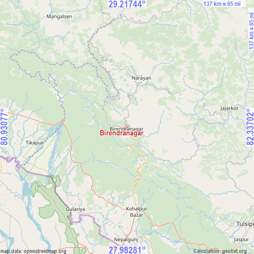
Birendranagar GPS coordinates[2]
28° 36' 6.984" North, 81° 38' 2.004" East
| Map corner | latitude | longitude |
|---|---|---|
| Upper-left | 29.21744°, | 80.93077° |
| Center: | 28.60194°, | 81.63389° |
| Lower-right: | 27.98281°, | 82.33702° |
| Map W x H: | 137.3×137.3 km | = 85.3×85.3mi |
| max Lat: | 30.04651° ⇑18.9% North |
| Birendranagar: | 28.60194° |
| min Lat: | ⇓81.1% South 26.45505° |
| min Long | Birendranagar | max Long |
| 80.17715° | 81.63389° | 88.09436° |
| W 13.5%⇐ | ⇒86.5% E |
Elevation
Elevation of Birendranagar is 736 m = 2415 ft, and this is 439.2 m = 1441 ft below average elevation for this country.
| Max E: |
5251 m = 17228 ft | 58.1% |
| Avg. | 1175.2 m = 3856 ft | |
| Birendranagar | 736 m = 2415 ft | |
Min E: |
72 m = 236 ft | 41.9% |
See also: Nepal elevation on elevation.city.
Geographical zone
Birendranagar is located in North temperate zone (between Tropic of Cancer and the Arctic Circle). Distance of this Northern Tropic circle is 574.3 km =356.9 mi to South.| Distance of | km | miles | from Birendranagar |
|---|---|---|---|
| North Pole | 6826.8 | 4242 | to North |
| Arctic Circle | 4220.9 | 2622.7 | to North |
| Tropic Cancer | 574.3 | 356.9 | to South |
| Equator | 3180.2 | 1976.1 | to South |


Nearby cities:
15 places around Birendranagar: (largest is in red/bold)
• Achhām
59.5 km =37 mi,  326°
326°
• Bardiyā
43.3 km =26.9 mi,  219°
219°
• Besisahar
86.5 km =53.7 mi,  118°
118°
• Bhojpur
75.4 km =46.9 mi,  169°
169°
• Dadeldhurā
128.4 km =79.8 mi,  307°
307°
• Dailekh
28 km =17.4 mi,  15°
15°
• Dhangaḍhi̇̄
102.5 km =63.7 mi,  276°
276°
• Dipayal
99.6 km =61.9 mi,  317°
317°
• Gulariyā
52.3 km =32.5 mi,  212°
212°
• Jumla
92 km =57.2 mi,  35°
35°
• Nepalgunj
61.4 km =38.2 mi,  181°
181°
• Salyān
58 km =36 mi, 115°
• Surkhet
17 km =10.6 mi, 123°
• Tulsīpur
83.4 km =51.8 mi,  128°
128°
• Ṭikāpur
51 km =31.7 mi,  260°
260°
Sources, notices
• [Note1] Compared only with cities in Nepal existing in our database
• [Src1] Map data: © OpenStreetMap contributors (CC-BY-SA)
• [Src2] Other city data from geonames.org with taken over terms of usage.
• [Src3] Geographical zone / Annual Mean Temperature by Robert A. Rohde @ Wikipedia
