Ailigandí geodata
Ailigandí (Guna Yala) is a populated place; located in Panama in America/Panama (GMT-5) time zone. With population of 1,652 people, there are 145 cities with bigger population in this country. Compared to other cities in Panama, 92.6% of cities are located further ↓South; 97% of cities are located further ←West and 99.4% of cities have higher elevation than Ailigandí. Note1


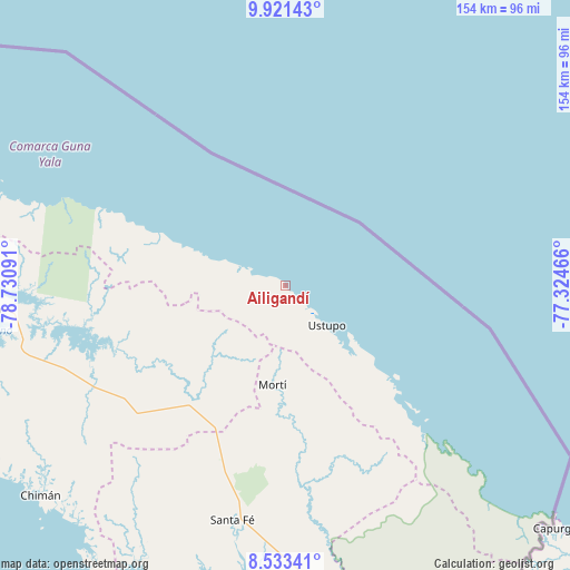
Ailigandí GPS coordinates[2]
9° 13' 41.16" North, 78° 1' 40.008" West
| Map corner | latitude | longitude |
|---|---|---|
| Upper-left | 9.92143°, | -78.73091° |
| Center: | 9.2281°, | -78.02778° |
| Lower-right: | 8.53341°, | -77.32466° |
| Map W x H: | 154.3×154.3 km | = 95.9×95.9mi |
| max Lat: | 9.60898° ⇑7.4% North |
| Ailigandí: | 9.2281° |
| min Lat: | ⇓92.6% South 7.26534° |
| min Long | Ailigandí | max Long |
| -82.91275° | -78.02778° | -77.38965° |
| W 97%⇐ | ⇒3% E |
Elevation
Elevation of Ailigandí is 3 m = 10 ft, and this is 169.1 m = 555 ft below average elevation for this country.
| Max E: |
2103 m = 6900 ft | 99.4% |
| Avg. | 172.1 m = 565 ft | |
| Ailigandí | 3 m = 10 ft | |
Min E: |
-1 m = -3 ft | 0.6% |
See also: Panama elevation on elevation.city.
Geographical zone
Ailigandí is located in North Torrid zone (between Equator and Tropic of Cancer). Distance of Equator is 1026.1 km =637.6 mi to South.| Distance of | km | miles | from Ailigandí |
|---|---|---|---|
| North Pole | 8981 | 5580.5 | to North |
| Arctic Circle | 6375.1 | 3961.3 | to North |
| Tropic Cancer | 1579.9 | 981.7 | to North |
| Equator | 1026.1 | 637.6 | to South |


Nearby cities:
15 places around Ailigandí: (largest is in red/bold)
• Achutupo
5.5 km =3.4 mi,  126°
126°
• Agua Fría Número Uno
45.1 km =28 mi,  204°
204°
• Cañazas
42.5 km =26.4 mi,  210°
210°
• Coetupo
51.8 km =32.2 mi, 134°
• Isla Tigre
58.6 km =36.4 mi,  292°
292°
• Mortí
43.3 km =26.9 mi,  172°
172°
• Mortí
43.5 km =27 mi,  163°
163°
• Mulatupo
43.6 km =27.1 mi,  135°
135°
• Platanilla
59.3 km =36.8 mi,  221°
221°
• Playón Chico
24.3 km =15.1 mi, 292°
• San Ignacio de Tupile
15.2 km =9.4 mi,  296°
296°
• Tortí
53.7 km =33.4 mi,  230°
230°
• Tubualá
47.7 km =29.6 mi, 135°
• Ualá
27.2 km =16.9 mi,  187°
187°
• Ustupo
15.5 km =9.6 mi, 134°
Sources, notices
• [Note1] Compared only with cities in Panama existing in our database
• [Src1] Map data: © OpenStreetMap contributors (CC-BY-SA)
• [Src2] Other city data from geonames.org with taken over terms of usage.
• [Src3] Geographical zone / Annual Mean Temperature by Robert A. Rohde @ Wikipedia
