Tubualá geodata
Tubualá (Guna Yala) is a populated place; located in Panama in America/Panama (GMT-5) time zone. With population of 877 people, there are 292 cities with bigger population in this country. Compared to other cities in Panama, 80% of cities are located further ↓South; 98.4% of cities are located further ←West and 96.3% of cities have higher elevation than Tubualá. Note1


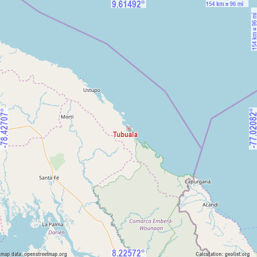
Tubualá GPS coordinates[2]
8° 55' 15.528" North, 77° 43' 26.184" West
| Map corner | latitude | longitude |
|---|---|---|
| Upper-left | 9.61492°, | -78.42707° |
| Center: | 8.92098°, | -77.72394° |
| Lower-right: | 8.22572°, | -77.02082° |
| Map W x H: | 154.5×154.5 km | = 96×96mi |
| max Lat: | 9.60898° ⇑20% North |
| Tubualá: | 8.92098° |
| min Lat: | ⇓80% South 7.26534° |
| min Long | Tubualá | max Long |
| -82.91275° | -77.72394° | -77.38965° |
| W 98.4%⇐ | ⇒1.6% E |
Elevation
Elevation of Tubualá is 6 m = 20 ft, and this is 166.1 m = 545 ft below average elevation for this country.
| Max E: |
2103 m = 6900 ft | 96.3% |
| Avg. | 172.1 m = 565 ft | |
| Tubualá | 6 m = 20 ft | |
Min E: |
-1 m = -3 ft | 3.7% |
See also: Panama elevation on elevation.city.
Geographical zone
Tubualá is located in North Torrid zone (between Equator and Tropic of Cancer). Distance of Equator is 991.9 km =616.3 mi to South.| Distance of | km | miles | from Tubualá |
|---|---|---|---|
| North Pole | 9015.1 | 5601.7 | to North |
| Arctic Circle | 6409.3 | 3982.6 | to North |
| Tropic Cancer | 1614 | 1002.9 | to North |
| Equator | 991.9 | 616.3 | to South |


Nearby cities:
15 places around Tubualá: (largest is in red/bold)
• Achutupo
42.3 km =26.3 mi,  316°
316°
• Agua Fría Número Uno
52.5 km =32.6 mi,  262°
262°
• Ailigandí
47.7 km =29.6 mi, 315°
• Armila
41.5 km =25.8 mi,  133°
133°
• Coetupo
4.1 km =2.5 mi,  124°
124°
• Metetí
54.6 km =33.9 mi,  210°
210°
• Mortí
22.5 km =14 mi,  250°
250°
• Mortí
29 km =18 mi, 252°
• Mulatupo
4.1 km =2.5 mi,  314°
314°
• Puerto Obaldía
43.9 km =27.3 mi, 130°
• Quebrada Honda
53.3 km =33.1 mi,  233°
233°
• Ualá
37.7 km =23.4 mi,  281°
281°
• Ustupo
32.2 km =20 mi, 316°
• Villa Darién
52.2 km =32.4 mi,  216°
216°
• Zapallal
53.9 km =33.5 mi,  235°
235°
Sources, notices
• [Note1] Compared only with cities in Panama existing in our database
• [Src1] Map data: © OpenStreetMap contributors (CC-BY-SA)
• [Src2] Other city data from geonames.org with taken over terms of usage.
• [Src3] Geographical zone / Annual Mean Temperature by Robert A. Rohde @ Wikipedia
