Port Moresby geodata
Port Moresby (National Capital) is a capital of a political entity; located in Papua New Guinea in Pacific/Port_Moresby (GMT+10) time zone. With population of 283,733 people, there are 0 cities with bigger population in this country. Compared to other cities in Papua New Guinea, 93.2% of cities are located further ↑North; 61.4% of cities are located further ←West and 97.7% of cities have higher elevation than Port Moresby. Note1


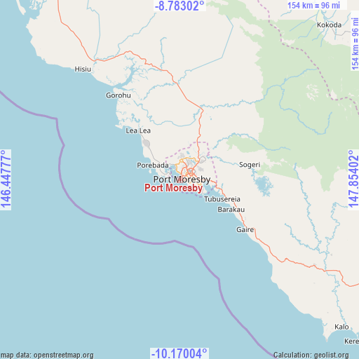
Port Moresby GPS coordinates[2]
9° 28' 38.028" South, 147° 9' 3.204" East
| Map corner | latitude | longitude |
|---|---|---|
| Upper-left | -8.78302°, | 146.44777° |
| Center: | -9.47723°, | 147.15089° |
| Lower-right: | -10.17004°, | 147.85402° |
| Map W x H: | 154.2×154.2 km | = 95.8×95.8mi |
| max Lat: | -2.0341° ⇑93.2% North |
| Port Moresby: | -9.47723° |
| min Lat: | ⇓6.8% South -10.61038° |
| min Long | Port Moresby | max Long |
| 141.29061° | 147.15089° | 155.69147° |
| W 61.4%⇐ | ⇒38.6% E |
Elevation
Elevation of Port Moresby is 1 m = 3 ft, and this is 580 m = 1903 ft below average elevation for this country.
| Max E: |
2248 m = 7375 ft | 97.7% |
| Avg. | 581 m = 1906 ft | |
| Port Moresby | 1 m = 3 ft | |
Min E: |
0 m = 0 ft | 2.3% |
See also: Port Moresby elevation on elevation.city.
Geographical zone
Port Moresby is located in South Torrid zone (between Equator and Tropic of Capricorn). Distance of Equator is 1053.8 km =654.8 mi to North.| Distance of | km | miles | from Port Moresby |
|---|---|---|---|
| Equator | 1053.8 | 654.8 | to North |
| Tropic Capricorn | 1552.1 | 964.4 | to South |
| Antarctic Circle | 6347.4 | 3944.1 | to South |
| South Pole | 8953.3 | 5563.3 | to South |


Nearby cities:
14 places around Port Moresby: (largest is in red/bold)
• Alotau
374 km =232.4 mi,  104°
104°
• Bulolo
259 km =160.9 mi,  347°
347°
• Daru
434.8 km =270.2 mi,  275°
275°
• Finschhafen
333.5 km =207.2 mi,  13°
13°
• Goroka
424.3 km =263.6 mi,  332°
332°
• Ihu
261.2 km =162.3 mi,  312°
312°
• Kainantu
381.7 km =237.2 mi,  338°
338°
• Kerema
226.7 km =140.9 mi,  318°
318°
• Kokoda
92.6 km =57.5 mi,  43°
43°
• Kwikila
67.5 km =41.9 mi,  124°
124°
• Lae
306.7 km =190.6 mi,  356°
356°
• Popondetta
142.7 km =88.7 mi,  56°
56°
• Samarai
404.5 km =251.3 mi,  108°
108°
• Wau
242.6 km =150.7 mi, 348°
Sources, notices
• [Note1] Compared only with cities in Papua New Guinea existing in our database
• [Src1] Map data: © OpenStreetMap contributors (CC-BY-SA)
• [Src2] Other city data from geonames.org with taken over terms of usage.
• [Src3] Geographical zone / Annual Mean Temperature by Robert A. Rohde @ Wikipedia
