Daru geodata
Daru (Western Province) is a seat of a first-order administrative division; located in Papua New Guinea in Pacific/Port_Moresby (GMT+10) time zone. With population of 15,214 people, there are 12 cities with bigger population in this country. Compared to other cities in Papua New Guinea, 90.9% of cities are located further ↑North; 84.1% of cities are located further →East and 72.7% of cities have higher elevation than Daru. Note1


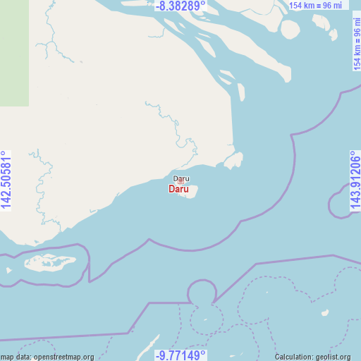
Daru GPS coordinates[2]
9° 4' 40.296" South, 143° 12' 32.148" East
| Map corner | latitude | longitude |
|---|---|---|
| Upper-left | -8.38289°, | 142.50581° |
| Center: | -9.07786°, | 143.20893° |
| Lower-right: | -9.77149°, | 143.91206° |
| Map W x H: | 154.4×154.4 km | = 95.9×95.9mi |
| max Lat: | -2.0341° ⇑90.9% North |
| Daru: | -9.07786° |
| min Lat: | ⇓9.1% South -10.61038° |
| min Long | Daru | max Long |
| 141.29061° | 143.20893° | 155.69147° |
| W 15.9%⇐ | ⇒84.1% E |
Elevation
Elevation of Daru is 11 m = 36 ft, and this is 570 m = 1870 ft below average elevation for this country.
| Max E: |
2248 m = 7375 ft | 72.7% |
| Avg. | 581 m = 1906 ft | |
| Daru | 11 m = 36 ft | |
Min E: |
0 m = 0 ft | 27.3% |
See also: Papua New Guinea elevation on elevation.city.
Geographical zone
Daru is located in South Torrid zone (between Equator and Tropic of Capricorn). Distance of Equator is 1009.4 km =627.2 mi to North.| Distance of | km | miles | from Daru |
|---|---|---|---|
| Equator | 1009.4 | 627.2 | to North |
| Tropic Capricorn | 1596.6 | 992.1 | to South |
| Antarctic Circle | 6391.8 | 3971.7 | to South |
| South Pole | 8997.7 | 5590.9 | to South |


Nearby cities:
15 places around Daru: (largest is in red/bold)
• Goroka
410.3 km =254.9 mi,  35°
35°
• Ialibu
322.7 km =200.5 mi,  15°
15°
• Ihu
273.9 km =170.2 mi,  61°
61°
• Kerema
308.1 km =191.4 mi,  66°
66°
• Kiunga
390.8 km =242.8 mi,  327°
327°
• Kundiawa
391.5 km =243.3 mi,  29°
29°
• Kurumul
391.1 km =243 mi, 23°
• Mendi
329.5 km =204.7 mi,  8°
8°
• Minj
388.5 km =241.4 mi, 24°
• Morehead
177.5 km =110.3 mi,  283°
283°
• Mount Hagen
375.4 km =233.3 mi, 17°
• Porgera
402 km =249.8 mi,  359°
359°
• Rauna
390.2 km =242.5 mi, 17°
• Tari
360.6 km =224.1 mi, 355°
• Wabag
402.8 km =250.3 mi, 8°
Sources, notices
• [Note1] Compared only with cities in Papua New Guinea existing in our database
• [Src1] Map data: © OpenStreetMap contributors (CC-BY-SA)
• [Src2] Other city data from geonames.org with taken over terms of usage.
• [Src3] Geographical zone / Annual Mean Temperature by Robert A. Rohde @ Wikipedia
