Kainantu geodata
Kainantu (Eastern Highlands) is a populated place; located in Papua New Guinea in Pacific/Port_Moresby (GMT+10) time zone. With population of 8,509 people, there are 19 cities with bigger population in this country. Compared to other cities in Papua New Guinea, 63.6% of cities are located further ↑North; 52.3% of cities are located further ←West and 77.3% of cities have lower elevation than Kainantu. Note1


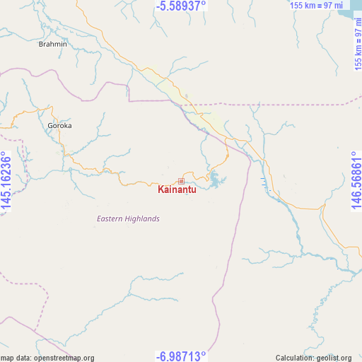
Kainantu GPS coordinates[2]
6° 17' 19.392" South, 145° 51' 55.728" East
| Map corner | latitude | longitude |
|---|---|---|
| Upper-left | -5.58937°, | 145.16236° |
| Center: | -6.28872°, | 145.86548° |
| Lower-right: | -6.98713°, | 146.56861° |
| Map W x H: | 155.4×155.4 km | = 96.6×96.6mi |
| max Lat: | -2.0341° ⇑63.6% North |
| Kainantu: | -6.28872° |
| min Lat: | ⇓36.4% South -10.61038° |
| min Long | Kainantu | max Long |
| 141.29061° | 145.86548° | 155.69147° |
| W 52.3%⇐ | ⇒47.7% E |
Elevation
Elevation of Kainantu is 1575 m = 5167 ft, and this is 994 m = 3261 ft above average elevation for this country.
| Max E: |
2248 m = 7375 ft | 22.7% |
| Kainantu | 1575 m 5167 ft | |
| Avg. | 581 m = 1906 ft | |
Min E: |
0 m = 0 ft | 77.3% |
See also: Papua New Guinea elevation on elevation.city.
Geographical zone
Kainantu is located in South Torrid zone (between Equator and Tropic of Capricorn). Distance of Equator is 699.2 km =434.5 mi to North.| Distance of | km | miles | from Kainantu |
|---|---|---|---|
| Equator | 699.2 | 434.5 | to North |
| Tropic Capricorn | 1906.7 | 1184.8 | to South |
| Antarctic Circle | 6701.9 | 4164.4 | to South |
| South Pole | 9307.8 | 5783.6 | to South |


Nearby cities:
15 places around Kainantu: (largest is in red/bold)
• Bulolo
132.9 km =82.6 mi,  139°
139°
• Finschhafen
220.9 km =137.3 mi,  97°
97°
• Goroka
57.6 km =35.8 mi,  293°
293°
• Ialibu
206.9 km =128.6 mi,  270°
270°
• Ihu
186.1 km =115.6 mi,  196°
196°
• Kerema
186.1 km =115.6 mi,  183°
183°
• Kundiawa
103.5 km =64.3 mi, 286°
• Kurumul
144.7 km =89.9 mi, 289°
• Lae
133.9 km =83.2 mi,  111°
111°
• Madang
119 km =73.9 mi,  355°
355°
• Mendi
244.7 km =152 mi, 273°
• Minj
136.5 km =84.8 mi, 288°
• Mount Hagen
187 km =116.2 mi,  284°
284°
• Rauna
184.9 km =114.9 mi, 289°
• Wau
149.8 km =93.1 mi, 141°
Sources, notices
• [Note1] Compared only with cities in Papua New Guinea existing in our database
• [Src1] Map data: © OpenStreetMap contributors (CC-BY-SA)
• [Src2] Other city data from geonames.org with taken over terms of usage.
• [Src3] Geographical zone / Annual Mean Temperature by Robert A. Rohde @ Wikipedia
