Kokoda geodata
Kokoda (Northern Province) is a seat of a second-order administrative division; located in Papua New Guinea in Pacific/Port_Moresby (GMT+10) time zone. With population of 6,199 people, there are 23 cities with bigger population in this country. Compared to other cities in Papua New Guinea, 88.6% of cities are located further ↑North; 68.2% of cities are located further ←West and 63.6% of cities have lower elevation than Kokoda. Note1


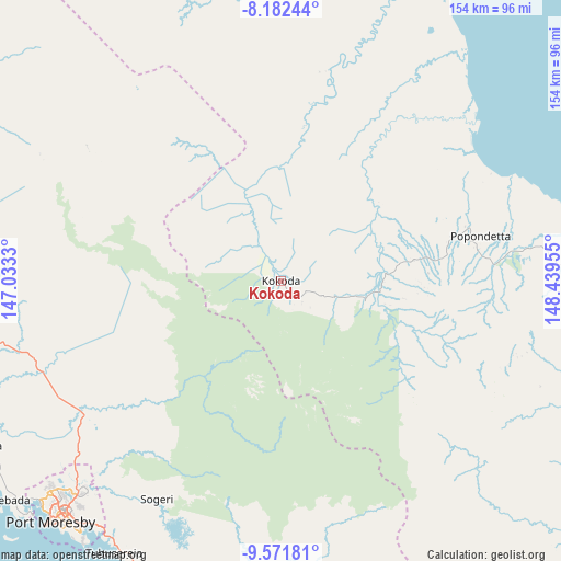
Kokoda GPS coordinates[2]
8° 52' 40.008" South, 147° 44' 11.112" East
| Map corner | latitude | longitude |
|---|---|---|
| Upper-left | -8.18244°, | 147.0333° |
| Center: | -8.87778°, | 147.73642° |
| Lower-right: | -9.57181°, | 148.43955° |
| Map W x H: | 154.5×154.5 km | = 96×96mi |
| max Lat: | -2.0341° ⇑88.6% North |
| Kokoda: | -8.87778° |
| min Lat: | ⇓11.4% South -10.61038° |
| min Long | Kokoda | max Long |
| 141.29061° | 147.73642° | 155.69147° |
| W 68.2%⇐ | ⇒31.8% E |
Elevation
Elevation of Kokoda is 372 m = 1220 ft, and this is 209 m = 686 ft below average elevation for this country.
| Max E: |
2248 m = 7375 ft | 36.4% |
| Avg. | 581 m = 1906 ft | |
| Kokoda | 372 m = 1220 ft | |
Min E: |
0 m = 0 ft | 63.6% |
See also: Papua New Guinea elevation on elevation.city.
Geographical zone
Kokoda is located in South Torrid zone (between Equator and Tropic of Capricorn). Distance of Equator is 987.1 km =613.4 mi to North.| Distance of | km | miles | from Kokoda |
|---|---|---|---|
| Equator | 987.1 | 613.4 | to North |
| Tropic Capricorn | 1618.8 | 1005.9 | to South |
| Antarctic Circle | 6414.1 | 3985.5 | to South |
| South Pole | 9019.9 | 5604.7 | to South |


Nearby cities:
15 places around Kokoda: (largest is in red/bold)
• Alotau
338.4 km =210.3 mi,  118°
118°
• Bulolo
221.9 km =137.9 mi,  327°
327°
• Finschhafen
258.2 km =160.4 mi,  2°
2°
• Goroka
404.4 km =251.3 mi,  320°
320°
• Ihu
279.8 km =173.9 mi,  292°
292°
• Kainantu
354.1 km =220 mi, 324°
• Kandrian
357.9 km =222.4 mi,  33°
33°
• Kerema
238.9 km =148.4 mi,  295°
295°
• Kundiawa
440.5 km =273.7 mi, 316°
• Kwikila
104.9 km =65.2 mi,  184°
184°
• Lae
253.1 km =157.3 mi,  341°
341°
• Popondetta
55.9 km =34.7 mi,  77°
77°
• Port Moresby
92.6 km =57.5 mi,  223°
223°
• Samarai
374 km =232.4 mi, 121°
• Wau
204.8 km =127.3 mi, 326°
Sources, notices
• [Note1] Compared only with cities in Papua New Guinea existing in our database
• [Src1] Map data: © OpenStreetMap contributors (CC-BY-SA)
• [Src2] Other city data from geonames.org with taken over terms of usage.
• [Src3] Geographical zone / Annual Mean Temperature by Robert A. Rohde @ Wikipedia
