Goroka geodata
Goroka (Eastern Highlands) is a seat of a first-order administrative division; located in Papua New Guinea in Pacific/Port_Moresby (GMT+10) time zone. With population of 18,503 people, there are 9 cities with bigger population in this country. Compared to other cities in Papua New Guinea, 52.3% of cities are located further ↓South; 56.8% of cities are located further →East and 72.7% of cities have lower elevation than Goroka. Note1


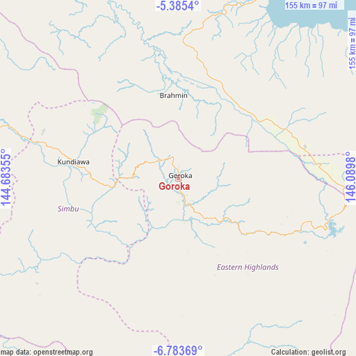
Goroka GPS coordinates[2]
6° 5' 6" South, 145° 23' 12.012" East
| Map corner | latitude | longitude |
|---|---|---|
| Upper-left | -5.3854°, | 144.68355° |
| Center: | -6.085°, | 145.38667° |
| Lower-right: | -6.78369°, | 146.0898° |
| Map W x H: | 155.5×155.5 km | = 96.6×96.6mi |
| max Lat: | -2.0341° ⇑47.7% North |
| Goroka: | -6.085° |
| min Lat: | ⇓52.3% South -10.61038° |
| min Long | Goroka | max Long |
| 141.29061° | 145.38667° | 155.69147° |
| W 43.2%⇐ | ⇒56.8% E |
Elevation
Elevation of Goroka is 1524 m = 5000 ft, and this is 943 m = 3094 ft above average elevation for this country.
| Max E: |
2248 m = 7375 ft | 27.3% |
| Goroka | 1524 m 5000 ft | |
| Avg. | 581 m = 1906 ft | |
Min E: |
0 m = 0 ft | 72.7% |
See also: Papua New Guinea elevation on elevation.city.
Geographical zone
Goroka is located in South Torrid zone (between Equator and Tropic of Capricorn). Distance of Equator is 676.6 km =420.4 mi to North.| Distance of | km | miles | from Goroka |
|---|---|---|---|
| Equator | 676.6 | 420.4 | to North |
| Tropic Capricorn | 1929.3 | 1198.8 | to South |
| Antarctic Circle | 6724.6 | 4178.5 | to South |
| South Pole | 9330.5 | 5797.7 | to South |


Nearby cities:
15 places around Goroka: (largest is in red/bold)
• Bulolo
186.1 km =115.6 mi,  131°
131°
• Ialibu
155.6 km =96.7 mi,  261°
261°
• Ihu
201.3 km =125.1 mi,  179°
179°
• Kainantu
57.6 km =35.8 mi,  113°
113°
• Kundiawa
46.7 km =29 mi,  278°
278°
• Kurumul
87.4 km =54.3 mi,  287°
287°
• Lae
191.5 km =119 mi, 111°
• Laiagam
195.5 km =121.5 mi,  295°
295°
• Madang
105.7 km =65.7 mi,  24°
24°
• Mendi
191.4 km =118.9 mi,  267°
267°
• Minj
79.4 km =49.3 mi, 284°
• Mount Hagen
130.3 km =81 mi, 281°
• Rauna
127.5 km =79.2 mi, 287°
• Wabag
195.7 km =121.6 mi, 289°
• Wau
202.4 km =125.8 mi, 133°
Sources, notices
• [Note1] Compared only with cities in Papua New Guinea existing in our database
• [Src1] Map data: © OpenStreetMap contributors (CC-BY-SA)
• [Src2] Other city data from geonames.org with taken over terms of usage.
• [Src3] Geographical zone / Annual Mean Temperature by Robert A. Rohde @ Wikipedia
