Kerema geodata
Kerema (Gulf) is a seat of a first-order administrative division; located in Papua New Guinea in Pacific/Port_Moresby (GMT+10) time zone. With population of 5,646 people, there are 25 cities with bigger population in this country. Compared to other cities in Papua New Guinea, 81.8% of cities are located further ↑North; 52.3% of cities are located further →East and 97.7% of cities have higher elevation than Kerema. Note1


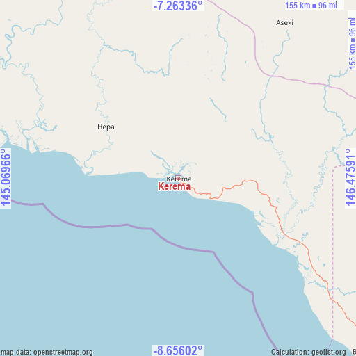
Kerema GPS coordinates[2]
7° 57' 37.008" South, 145° 46' 22.008" East
| Map corner | latitude | longitude |
|---|---|---|
| Upper-left | -7.26336°, | 145.06966° |
| Center: | -7.96028°, | 145.77278° |
| Lower-right: | -8.65602°, | 146.47591° |
| Map W x H: | 154.8×154.9 km | = 96.2×96.3mi |
| max Lat: | -2.0341° ⇑81.8% North |
| Kerema: | -7.96028° |
| min Lat: | ⇓18.2% South -10.61038° |
| min Long | Kerema | max Long |
| 141.29061° | 145.77278° | 155.69147° |
| W 47.7%⇐ | ⇒52.3% E |
Elevation
Elevation of Kerema is 1 m = 3 ft, and this is 580 m = 1903 ft below average elevation for this country.
| Max E: |
2248 m = 7375 ft | 97.7% |
| Avg. | 581 m = 1906 ft | |
| Kerema | 1 m = 3 ft | |
Min E: |
0 m = 0 ft | 2.3% |
See also: Papua New Guinea elevation on elevation.city.
Geographical zone
Kerema is located in South Torrid zone (between Equator and Tropic of Capricorn). Distance of Equator is 885.1 km =550 mi to North.| Distance of | km | miles | from Kerema |
|---|---|---|---|
| Equator | 885.1 | 550 | to North |
| Tropic Capricorn | 1720.8 | 1069.3 | to South |
| Antarctic Circle | 6516.1 | 4048.9 | to South |
| South Pole | 9122 | 5668.1 | to South |


Nearby cities:
15 places around Kerema: (largest is in red/bold)
• Bulolo
127.3 km =79.1 mi,  48°
48°
• Finschhafen
276.8 km =172 mi,  55°
55°
• Goroka
212.8 km =132.2 mi,  348°
348°
• Ialibu
270.8 km =168.3 mi,  313°
313°
• Ihu
42.3 km =26.3 mi,  279°
279°
• Kainantu
186.1 km =115.6 mi,  3°
3°
• Kokoda
238.9 km =148.4 mi,  115°
115°
• Kundiawa
233.3 km =145 mi,  337°
337°
• Kurumul
265.8 km =165.2 mi,  331°
331°
• Lae
192.7 km =119.7 mi,  44°
44°
• Minj
257.6 km =160.1 mi, 332°
• Mount Hagen
289.2 km =179.7 mi,  323°
323°
• Popondetta
285 km =177.1 mi,  108°
108°
• Port Moresby
226.7 km =140.9 mi,  138°
138°
• Wau
124.9 km =77.6 mi, 56°
Sources, notices
• [Note1] Compared only with cities in Papua New Guinea existing in our database
• [Src1] Map data: © OpenStreetMap contributors (CC-BY-SA)
• [Src2] Other city data from geonames.org with taken over terms of usage.
• [Src3] Geographical zone / Annual Mean Temperature by Robert A. Rohde @ Wikipedia
