Madang geodata
Madang is a seat of a first-order administrative division; located in Papua New Guinea in Pacific/Port_Moresby (GMT+10) time zone. With population of 27,419 people, there are 5 cities with bigger population in this country. Compared to other cities in Papua New Guinea, 79.5% of cities are located further ↓South; 50% of cities are located further ←West and 97.7% of cities have higher elevation than Madang. Note1


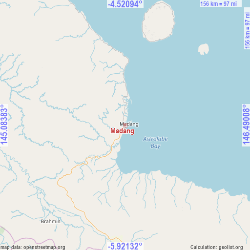
Madang GPS coordinates[2]
5° 13' 17.472" South, 145° 47' 13.02" East
| Map corner | latitude | longitude |
|---|---|---|
| Upper-left | -4.52094°, | 145.08383° |
| Center: | -5.22152°, | 145.78695° |
| Lower-right: | -5.92132°, | 146.49008° |
| Map W x H: | 155.7×155.7 km | = 96.7×96.7mi |
| max Lat: | -2.0341° ⇑20.5% North |
| Madang: | -5.22152° |
| min Lat: | ⇓79.5% South -10.61038° |
| min Long | Madang | max Long |
| 141.29061° | 145.78695° | 155.69147° |
| W 50%⇐ | ⇒50% E |
Elevation
Elevation of Madang is 1 m = 3 ft, and this is 580 m = 1903 ft below average elevation for this country.
| Max E: |
2248 m = 7375 ft | 97.7% |
| Avg. | 581 m = 1906 ft | |
| Madang | 1 m = 3 ft | |
Min E: |
0 m = 0 ft | 2.3% |
See also: Papua New Guinea elevation on elevation.city.
Geographical zone
Madang is located in South Torrid zone (between Equator and Tropic of Capricorn). Distance of Equator is 580.6 km =360.8 mi to North.| Distance of | km | miles | from Madang |
|---|---|---|---|
| Equator | 580.6 | 360.8 | to North |
| Tropic Capricorn | 2025.3 | 1258.5 | to South |
| Antarctic Circle | 6820.6 | 4238.1 | to South |
| South Pole | 9426.5 | 5857.4 | to South |


Nearby cities:
15 places around Madang: (largest is in red/bold)
• Angoram
230.2 km =143 mi,  304°
304°
• Bulolo
239.7 km =148.9 mi,  156°
156°
• Goroka
105.7 km =65.7 mi,  204°
204°
• Ialibu
230.8 km =143.4 mi,  239°
239°
• Kainantu
119 km =73.9 mi,  175°
175°
• Kundiawa
126.7 km =78.7 mi,  225°
225°
• Kurumul
146 km =90.7 mi, 241°
• Lae
213.9 km =132.9 mi,  141°
141°
• Laiagam
221.4 km =137.6 mi,  266°
266°
• Mendi
257.2 km =159.8 mi,  246°
246°
• Minj
143.2 km =89 mi, 237°
• Mount Hagen
186.2 km =115.7 mi, 247°
• Rauna
175.5 km =109.1 mi, 250°
• Wabag
230.6 km =143.3 mi,  262°
262°
• Wau
256.8 km =159.6 mi, 156°
Sources, notices
• [Note1] Compared only with cities in Papua New Guinea existing in our database
• [Src1] Map data: © OpenStreetMap contributors (CC-BY-SA)
• [Src2] Other city data from geonames.org with taken over terms of usage.
• [Src3] Geographical zone / Annual Mean Temperature by Robert A. Rohde @ Wikipedia
