Kulachi geodata
Kulachi (Khyber Pakhtunkhwa) is a populated place; located in Pakistan in Asia/Karachi (GMT+5) time zone. With population of 22,376 people, there are 257 cities with bigger population in this country. Compared to other cities in Pakistan, 65.2% of cities are located further ↓South; 60.3% of cities are located further →East and 64.8% of cities have lower elevation than Kulachi. Note1


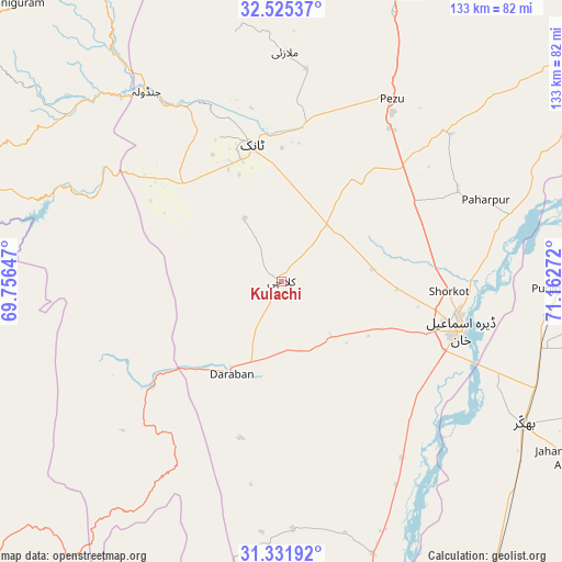
Kulachi GPS coordinates[2]
31° 55' 50.088" North, 70° 27' 34.524" East
| Map corner | latitude | longitude |
|---|---|---|
| Upper-left | 32.52537°, | 69.75647° |
| Center: | 31.93058°, | 70.45959° |
| Lower-right: | 31.33192°, | 71.16272° |
| Map W x H: | 132.7×132.7 km | = 82.5×82.5mi |
| max Lat: | 36.32162° ⇑34.8% North |
| Kulachi: | 31.93058° |
| min Lat: | ⇓65.2% South 24.14422° |
| min Long | Kulachi | max Long |
| 61.74573° | 70.45959° | 75.63372° |
| W 39.7%⇐ | ⇒60.3% E |
Elevation
Elevation of Kulachi is 218 m = 715 ft, and this is 127 m = 417 ft below average elevation for this country.
| Max E: |
2732 m = 8963 ft | 35.2% |
| Avg. | 345 m = 1132 ft | |
| Kulachi | 218 m = 715 ft | |
Min E: |
3 m = 10 ft | 64.8% |
See also: Pakistan elevation on elevation.city.
Geographical zone
Kulachi is located in North temperate zone (between Tropic of Cancer and the Arctic Circle). Distance of this Northern Tropic circle is 944.4 km =586.8 mi to South.| Distance of | km | miles | from Kulachi |
|---|---|---|---|
| North Pole | 6456.7 | 4012 | to North |
| Arctic Circle | 3850.8 | 2392.8 | to North |
| Tropic Cancer | 944.4 | 586.8 | to South |
| Equator | 3550.3 | 2206.1 | to South |


Nearby cities:
15 places around Kulachi: (largest is in red/bold)
• Bhakkar
66.4 km =41.3 mi,  120°
120°
• Chak Two Hundred Forty-nine Thal Development Authority
109.5 km =68 mi,  139°
139°
• Darya Khan
62.8 km =39 mi,  104°
104°
• Dera Ismail Khan
43.2 km =26.8 mi, 104°
• Dullewala
92.8 km =57.7 mi, 96°
• Gulishah Kach
83.1 km =51.6 mi,  352°
352°
• Harnoli
110.1 km =68.4 mi,  69°
69°
• Kalur Kot
80 km =49.7 mi, 71°
• Karor
91.3 km =56.7 mi,  149°
149°
• Lakki
86.4 km =53.7 mi,  29°
29°
• Paharpur
51.9 km =32.2 mi, 68°
• Sarai Naurang
104 km =64.6 mi,  16°
16°
• Shorkot
39.5 km =24.5 mi,  93°
93°
• Tank
32.7 km =20.3 mi, 347°
• Wana
93 km =57.8 mi,  296°
296°
Sources, notices
• [Note1] Compared only with cities in Pakistan existing in our database
• [Src1] Map data: © OpenStreetMap contributors (CC-BY-SA)
• [Src2] Other city data from geonames.org with taken over terms of usage.
• [Src3] Geographical zone / Annual Mean Temperature by Robert A. Rohde @ Wikipedia
