Górowo Iławeckie geodata
Górowo Iławeckie (Warmia-Masuria) is a seat of a third-order administrative division; located in Poland in Europe/Warsaw (GMT+2) time zone. With population of 4,900 people, there are 696 cities with bigger population in this country. Compared to other cities in Poland, 97.5% of cities are located further ↓South; 65% of cities are located further ←West and 69.3% of cities have higher elevation than Górowo Iławeckie. Note1
Administrative division(s):
- Level 1: Warmia-Masuria
- Level 2: Powiat bartoszycki
- Level 3: Górowo Iławeckie


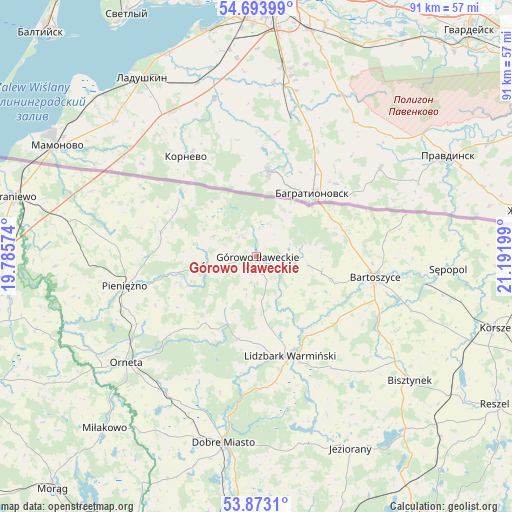
Górowo Iławeckie GPS coordinates[2]
54° 17' 8.124" North, 20° 29' 19.896" East
| Map corner | latitude | longitude |
|---|---|---|
| Upper-left | 54.69399°, | 19.78574° |
| Center: | 54.28559°, | 20.48886° |
| Lower-right: | 53.8731°, | 21.19199° |
| Map W x H: | 91.3×91.3 km | = 56.7×56.7mi |
| max Lat: | 54.83135° ⇑2.5% North |
| Górowo Iławeckie: | 54.28559° |
| min Lat: | ⇓97.5% South 49.21328° |
| min Long | Górowo Iławec | max Long |
| 14.20249° | 20.48886° | 24.03723° |
| W 65%⇐ | ⇒35% E |
Elevation
Elevation of Górowo Iławeckie is 122 m = 400 ft, and this is 69.4 m = 228 ft below average elevation for this country.
| Max E: |
974 m = 3196 ft | 69.3% |
| Avg. | 191.4 m = 628 ft | |
| Górowo Iławeckie | 122 m = 400 ft | |
Min E: |
-3 m = -10 ft | 30.7% |
See also: Poland elevation on elevation.city.
Geographical zone
Górowo Iławeckie is located in North temperate zone (between Tropic of Cancer and the Arctic Circle). Distance of this North polar circle is 1365.2 km =848.3 mi to North.| Distance of | km | miles | from Górowo Iławeckie |
|---|---|---|---|
| North Pole | 3971.1 | 2467.5 | to North |
| Arctic Circle | 1365.2 | 848.3 | to North |
| Tropic Cancer | 3430.1 | 2131.4 | to South |
| Equator | 6036 | 3750.6 | to South |


Nearby cities:
15 places around Górowo Iławeckie: (largest is in red/bold)
• Bartoszyce
21 km =13 mi,  99°
99°
• Bisztynek
34.8 km =21.6 mi,  129°
129°
• Braniewo
44.6 km =27.7 mi,  283°
283°
• Dobre Miasto
33.8 km =21 mi,  190°
190°
• Janikowo
7.3 km =4.5 mi, 194°
• Jeziorany
38.3 km =23.8 mi,  154°
154°
• Korsze
44.2 km =27.5 mi,  106°
106°
• Lelkowo
17.7 km =11 mi, 284°
• Lidzbark Warmiński
18.7 km =11.6 mi,  161°
161°
• Lubomino
29.2 km =18.1 mi,  213°
213°
• Miłakowo
41 km =25.5 mi,  221°
221°
• Orneta
29.9 km =18.6 mi,  230°
230°
• Pieniężno
24 km =14.9 mi,  256°
256°
• Sępopol
34.2 km =21.3 mi,  93°
93°
• Świątki
43 km =26.7 mi,  201°
201°
Sources, notices
• [Note1] Compared only with cities in Poland existing in our database
• [Src1] Map data: © OpenStreetMap contributors (CC-BY-SA)
• [Src2] Other city data from geonames.org with taken over terms of usage.
• [Src3] Geographical zone / Annual Mean Temperature by Robert A. Rohde @ Wikipedia
