Sulţānah geodata
Sulţānah (Al Madīnah al Munawwarah) is a populated place; located in Saudi Arabia in Asia/Riyadh (GMT+3) time zone. With population of 946,697 people, there are 4 cities with bigger population in this country. Compared to other cities in Saudi Arabia, 62.9% of cities are located further ↑North; 87.6% of cities are located further →East and 59.8% of cities have lower elevation than Sulţānah. Note1


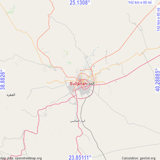
Sulţānah GPS coordinates[2]
24° 29' 33.288" North, 39° 35' 8.592" East
| Map corner | latitude | longitude |
|---|---|---|
| Upper-left | 25.1308°, | 38.8826° |
| Center: | 24.49258°, | 39.58572° |
| Lower-right: | 23.85111°, | 40.28885° |
| Map W x H: | 142.3×142.3 km | = 88.4×88.4mi |
| max Lat: | 31.67252° ⇑62.9% North |
| Sulţānah: | 24.49258° |
| min Lat: | ⇓37.1% South 16.57946° |
| min Long | Sulţānah | max Long |
| 35.69014° | 39.58572° | 54.09599° |
| W 12.4%⇐ | ⇒87.6% E |
Elevation
Elevation of Sulţānah is 597 m = 1959 ft, and this is 75.6 m = 248 ft above average elevation for this country.
| Max E: |
2385 m = 7825 ft | 40.2% |
| Sulţānah | 597 m 1959 ft | |
| Avg. | 521.4 m = 1711 ft | |
Min E: |
3 m = 10 ft | 59.8% |
See also: Sulţānah elevation on elevation.city.
Geographical zone
Sulţānah is located in North temperate zone (between Tropic of Cancer and the Arctic Circle). Distance of this Northern Tropic circle is 117.4 km =72.9 mi to South.| Distance of | km | miles | from Sulţānah |
|---|---|---|---|
| North Pole | 7283.7 | 4525.9 | to North |
| Arctic Circle | 4677.9 | 2906.7 | to North |
| Tropic Cancer | 117.4 | 72.9 | to South |
| Equator | 2723.3 | 1692.2 | to South |


Nearby cities:
15 places around Sulţānah: (largest is in red/bold)
• Afif
344.1 km =213.8 mi,  100°
100°
• Al Hadā
354.8 km =220.5 mi,  168°
168°
• Al Jumūm
319.9 km =198.8 mi,  177°
177°
• Al Muwayh
318.6 km =198 mi,  135°
135°
• Al-`Ula
288.4 km =179.2 mi,  324°
324°
• Alrmtheiah
341.7 km =212.3 mi,  85°
85°
• Badr Ḩunayn
112.9 km =70.2 mi,  225°
225°
• Jeddah
330.4 km =205.3 mi,  186°
186°
• Mecca
341.8 km =212.4 mi, 175°
• Medina
3.9 km =2.4 mi,  132°
132°
• Rābigh
196.5 km =122.1 mi,  196°
196°
• Ta’if
368.2 km =228.8 mi, 166°
• Umm Lajj
241.2 km =149.9 mi,  284°
284°
• Wed Alnkil
343.5 km =213.4 mi,  72°
72°
• Yanbu
160.8 km =99.9 mi,  253°
253°
Sources, notices
• [Note1] Compared only with cities in Saudi Arabia existing in our database
• [Src1] Map data: © OpenStreetMap contributors (CC-BY-SA)
• [Src2] Other city data from geonames.org with taken over terms of usage.
• [Src3] Geographical zone / Annual Mean Temperature by Robert A. Rohde @ Wikipedia
