Ta’if geodata
Ta’if (Makkah) is a populated place; located in Saudi Arabia in Asia/Riyadh (GMT+3) time zone. With population of 530,848 people, there are 6 cities with bigger population in this country. Compared to other cities in Saudi Arabia, 78.4% of cities are located further ↑North; 79.4% of cities are located further →East and 92.8% of cities have lower elevation than Ta’if. Note1


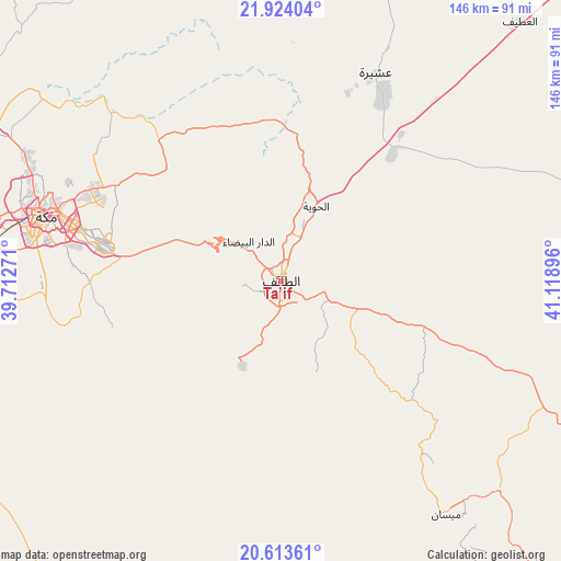
Ta’if GPS coordinates[2]
21° 16' 13.008" North, 40° 24' 56.988" East
| Map corner | latitude | longitude |
|---|---|---|
| Upper-left | 21.92404°, | 39.71271° |
| Center: | 21.27028°, | 40.41583° |
| Lower-right: | 20.61361°, | 41.11896° |
| Map W x H: | 145.7×145.7 km | = 90.5×90.5mi |
| max Lat: | 31.67252° ⇑78.4% North |
| Ta’if: | 21.27028° |
| min Lat: | ⇓21.6% South 16.57946° |
| min Long | Ta’if | max Long |
| 35.69014° | 40.41583° | 54.09599° |
| W 20.6%⇐ | ⇒79.4% E |
Elevation
Elevation of Ta’if is 1672 m = 5486 ft, and this is 1150.6 m = 3775 ft above average elevation for this country.
| Max E: |
2385 m = 7825 ft | 7.2% |
| Ta’if | 1672 m 5486 ft | |
| Avg. | 521.4 m = 1711 ft | |
Min E: |
3 m = 10 ft | 92.8% |
See also: Ta’if elevation on elevation.city.
Geographical zone
Ta’if is located in North Torrid zone (between Equator and Tropic of Cancer). Distance of this Northern Tropic circle is 240.9 km =149.7 mi to North.| Distance of | km | miles | from Ta’if |
|---|---|---|---|
| North Pole | 7642 | 4748.5 | to North |
| Arctic Circle | 5036.1 | 3129.3 | to North |
| Tropic Cancer | 240.9 | 149.7 | to North |
| Equator | 2365 | 1469.5 | to South |


Nearby cities:
15 places around Ta’if: (largest is in red/bold)
• Al Bahah
177.6 km =110.4 mi,  141°
141°
• Al Hadā
17.2 km =10.7 mi,  309°
309°
• Al Jumūm
83.7 km =52 mi,  297°
297°
• Al Majāridah
285.2 km =177.2 mi,  146°
146°
• Al Mindak
153 km =95.1 mi, 143°
• Al Muwayh
189.5 km =117.7 mi,  46°
46°
• An Nimāş
295.7 km =183.7 mi, 143°
• Ash Shafā
24.5 km =15.2 mi,  206°
206°
• Badr Ḩunayn
325.4 km =202.2 mi,  329°
329°
• Jeddah
129.7 km =80.6 mi,  283°
283°
• Mecca
63.5 km =39.5 mi,  285°
285°
• Qal‘at Bīshah
268 km =166.5 mi,  121°
121°
• Rābigh
221.7 km =137.8 mi,  320°
320°
• Tabālah
253.4 km =157.5 mi,  125°
125°
• Turabah
126.3 km =78.5 mi,  92°
92°
Sources, notices
• [Note1] Compared only with cities in Saudi Arabia existing in our database
• [Src1] Map data: © OpenStreetMap contributors (CC-BY-SA)
• [Src2] Other city data from geonames.org with taken over terms of usage.
• [Src3] Geographical zone / Annual Mean Temperature by Robert A. Rohde @ Wikipedia
