Rābigh geodata
Rābigh (Makkah) is a populated place; located in Saudi Arabia in Asia/Riyadh (GMT+3) time zone. With population of 41,759 people, there are 40 cities with bigger population in this country. Compared to other cities in Saudi Arabia, 71.1% of cities are located further ↑North; 89.7% of cities are located further →East and 92.8% of cities have higher elevation than Rābigh. Note1


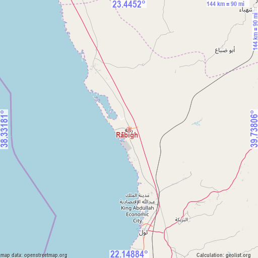
Rābigh GPS coordinates[2]
22° 47' 54.816" North, 39° 2' 5.748" East
| Map corner | latitude | longitude |
|---|---|---|
| Upper-left | 23.4452°, | 38.33181° |
| Center: | 22.79856°, | 39.03493° |
| Lower-right: | 22.14884°, | 39.73806° |
| Map W x H: | 144.1×144.1 km | = 89.5×89.5mi |
| max Lat: | 31.67252° ⇑71.1% North |
| Rābigh: | 22.79856° |
| min Lat: | ⇓28.9% South 16.57946° |
| min Long | Rābigh | max Long |
| 35.69014° | 39.03493° | 54.09599° |
| W 10.3%⇐ | ⇒89.7% E |
Elevation
Elevation of Rābigh is 7 m = 23 ft, and this is 514.4 m = 1688 ft below average elevation for this country.
| Max E: |
2385 m = 7825 ft | 92.8% |
| Avg. | 521.4 m = 1711 ft | |
| Rābigh | 7 m = 23 ft | |
Min E: |
3 m = 10 ft | 7.2% |
See also: Rābigh elevation on elevation.city.
Geographical zone
Rābigh is located in North Torrid zone (between Equator and Tropic of Cancer). Distance of this Northern Tropic circle is 71 km =44.1 mi to North.| Distance of | km | miles | from Rābigh |
|---|---|---|---|
| North Pole | 7472.1 | 4642.9 | to North |
| Arctic Circle | 4866.2 | 3023.7 | to North |
| Tropic Cancer | 71 | 44.1 | to North |
| Equator | 2535 | 1575.2 | to South |


Nearby cities:
15 places around Rābigh: (largest is in red/bold)
• Al Bahah
399.2 km =248.1 mi,  140°
140°
• Al Hadā
204.8 km =127.3 mi, 140°
• Al Jumūm
148.1 km =92 mi,  152°
152°
• Al Mindak
374.5 km =232.7 mi, 141°
• Al Muwayh
282.5 km =175.5 mi,  98°
98°
• Ash Shafā
232.8 km =144.7 mi, 145°
• Badr Ḩunayn
112.3 km =69.8 mi,  347°
347°
• Jeddah
140.7 km =87.4 mi,  173°
173°
• Mecca
172.9 km =107.4 mi, 151°
• Medina
194.8 km =121 mi,  17°
17°
• Sulţānah
196.5 km =122.1 mi, 16°
• Ta’if
221.7 km =137.8 mi, 140°
• Turabah
320.6 km =199.2 mi,  123°
123°
• Umm Lajj
305.5 km =189.8 mi,  324°
324°
• Yanbu
174.5 km =108.4 mi,  325°
325°
Sources, notices
• [Note1] Compared only with cities in Saudi Arabia existing in our database
• [Src1] Map data: © OpenStreetMap contributors (CC-BY-SA)
• [Src2] Other city data from geonames.org with taken over terms of usage.
• [Src3] Geographical zone / Annual Mean Temperature by Robert A. Rohde @ Wikipedia
